


Get from Medellin to Guatape on your own with this step-by-step guide. Plus, how to climb La Piedra with NO crowds, the perfect 1-day itinerary, and the gorgeous village nearby that most travelers miss.

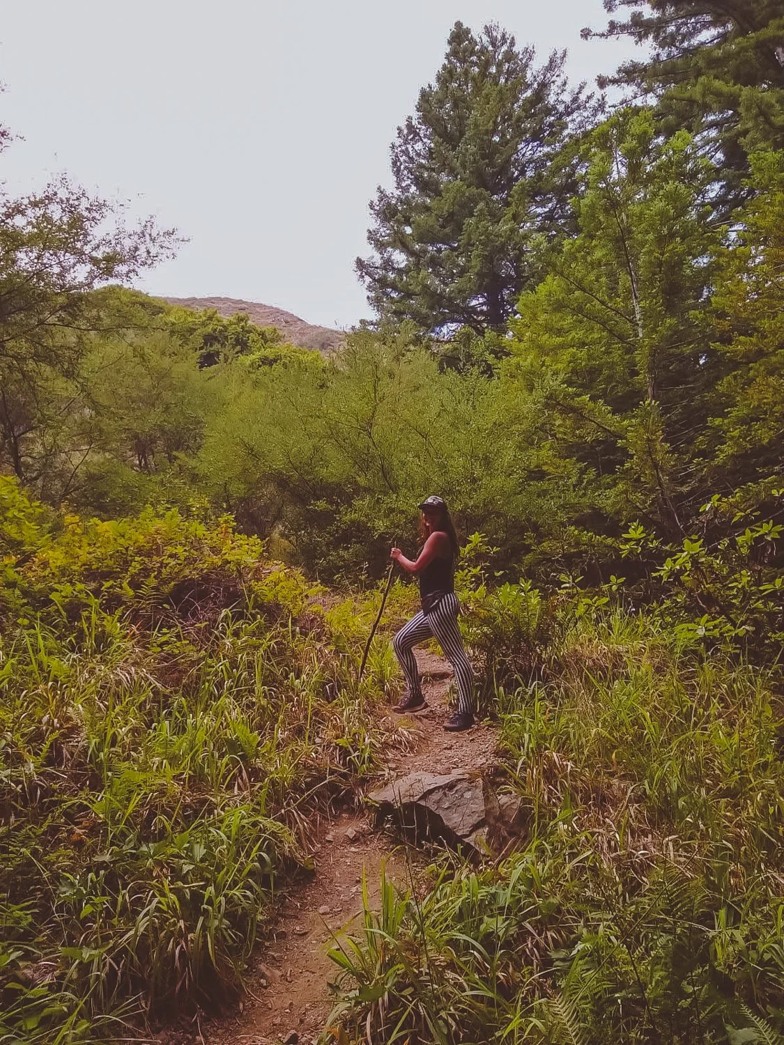
The guide with EVERYTHING you need to plan your trip to the ever-growing coffee region - including full itineraries, which towns to visit, how to get around, what to pack, and more.
In 3 days, experience the cultural renaissance of Colombia’s vibrant port city, now known as a global destination for its sunshine, art, dance, architecture, and tropical islands.
How many days do you really need in Colombia’s sunny hub? Check out my ideal itinerary, the best things to do, and day trips from Medellin!
Colombia has diverse climates and fashions in each city. So what should I wear in Colombia? This list includes comfort, convenience, and style for all my ladies asking themselves the same question.
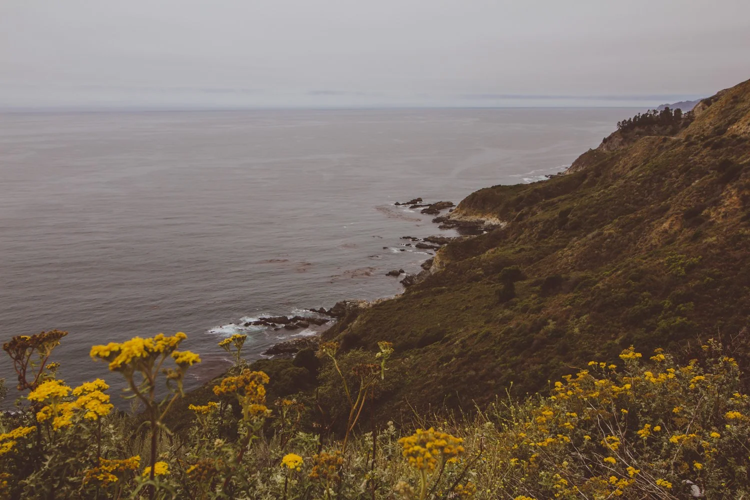
Are you heading on a Big Sur drive soon? Do you love waterfalls, hiking, beaches, wildlife…
…and being out of contact from the rest of the world?
Then read on because I am about to share my secrets with you, fellow budget traveler, with these 11 free things to do along the remote coast of Big Sur, California.
I’m a California native who has driven allll the way up and down our large state (from Mexico to Oregon and back) several times - both on my own and with friends.
I’ve written this article from my own recent experience doing the Big Sur drive post-pandemic with a friend. The untouched beach bluffs that greet you with a different personality every morning remain a photographer’s dream!
Note: Before you hit up these free things to do on your Big Sur drive, you absolutely need to make sure you have maps downloaded offline since the internet will not work at all on this remote coast. You can use the free app maps.me to download the map of California. Make sure you save all these locations beforehand, so you have all the hiking trails and campsite locations. You’ll need them.
Now, get ready to hit the road!

Your Big Sur drive is the place to unplug, get lost, and find your spirit along the unforgiving coastline.
Dark, brooding beaches exist without another pair of footprints in sight.
Purple sand sprawls next to thick sea stars chilling on rocks, while miniature crabs scuttle about.
Sparkling lime waterfalls surprise hikers at the end of miles and miles of overgrown forest trails.
And bushels of poison oak claw at you from every corner.
I spent 5 days with no cell service exploring the longest stretch of undisturbed coast in the United States: Big Sur, California.
90 miles along Pacific Coast Highway 1 in Central California from Carmel to San Simeon brims of rocky beaches with character and redwood mountains so steep they’ll bang up any car smaller than a Jeep.
Upon arrival, it is easy to understand why Big Sur glitters majestic.
For rugged campers or backpackers, the solitude experienced on the Big Sur drive is a dream. You must have an offline map to find your way around the less-visited landscape, while families will probably stick to the state parks.
Besides privacy, the preservation of the area maintains that Big Sur will always stay true; the flora and fauna will (hopefully) continue to flourish, and it gives people a chance to see how beautiful California would be without infrastructure.

Lastly, Big Sur wows due to its affordability. If you are craving a getaway and know how to pitch a tent, you can visit Big Sur for the price of food and gas.
I will note that state parks charge $10 for cars, but there are ways to get in free as well which I will detail below.
Ok Wolfette, here are 11 free things to do on your Big Sur drive in California, from a local:
Location on Google Maps: Elephant Seal Vista Point

Those aren’t rocks… they’re elephant seals laying down!
Our first Southern stop on the way to Big Sur proper was an unexpected turn at the Elephant Seal viewing area in San Simeon.
Don’t let the mellow photo fool you. These elephant seals play-fought in the water together and bounced along the shores until we experienced cuteness overload.
Yes, it’s free like everything else on this list. You’ll just stop on the side of the highway for your up close encounters with wildlife.
Location on Google Maps: Salmon Creek Trailhead
Hiking distance: 0.3 miles

Wow! These gorgeous, green falls at Salmon Creek reside just a short walk from highway 1, so no strenuous hiking is involved.
Keep an eye out as you map your Big Sur drive, because you’ll have to quickly park at the side of the road (no parking lot) on a busy bend of highway.
Wade, swim, and jump in the emerald pool to cool off. If you desire a longer hike, you can continue up the trail to Upper Salmon Creek Falls, about 5 miles round trip.
Location on Google Maps: Ragged Point Inn & Resort
Hiking distance: 0.8 miles
Ragged Point is a steep hike that leads you down the cliff to a gorgeous, quiet sandy beach where you will probably be alone, due to the nature of the trail.
You will park in the same parking lot as Ragged Point Inn & Resort, with the trailhead behind the hotel.
To make the descent safely, you’ll want athletic shoes with traction since the loose dirt tended to slide underneath your feet.
We had fun stomping and jumping around the round rocks at the bottom and finding our own hideaways for about an hour.
Location on Google Maps: Nathaniel Owings Memorial Redwood Grove
Hiking distance: 0.6 miles
We missed the stop at Redwood Gulch, because no sign warned us along the road. After turning around and going back to the coordinates of the unmarked turnoff, we spotted a thin beige path.


This unassuming path led us to the location of the southernmost Redwood trees, lining a watering hole perfect for a skinny dip.
The humble falls and musky forest seemed to be plucked out of a fairytale. (Any 90’s babies remember the cartoon forest nymph, Fern Gully?).
Location on Google Maps: Sand Dollar Beach
Sand Dollar Beach might possibly be our favorite beach in California.
We discovered several spacious caves on the edge of the beach, large enough to walk around in and relax. The caves resembled secret auditoriums, a shaded paradise away from the world while we lazily peered out at the blue horizon.
In addition to private caves, the beauty and adventure lured us in. The water appeared so clear and pristine that you could see each grain of sand beside your toes. The sky reflected off the sand, projecting an infinite sapphire vortex.
To avoid any fees, simply park on the street outside of the parking lot.
Location: Hidden (Details below)

Big Sur’s low-brewing clouds prove eerily reminiscent of a James Bond film, paired with boosted high mountains that call in the heavens.
Although most official campgrounds were listed around $40-$70 per night, you can save the cash and camp for free in several astounding locations throughout Big Sur.
Instead of giving away all the secrets here and exposing the spots, I recommend you use the apps and websites Campendium, Boondocking, or freecampsites.net to check out the updated campsites that other reviewers have listed. These are the tools I always use on my primitive camping journey, along with maps.me.
A lot of these camp spots require a four-wheel drive vehicle to reach them (we learned the hard way) and may be unofficial, but they will usually be free.
Other non-free options include looking on Hipcamp (like Airbnb, but for camping) or camping within the state parks and official campgrounds (Kirk Creek campground has an awesome view!).
Location on Google Maps: Mill Creek Trailhead
Hiking distance: 2.3 miles
Zip down the mile-or-so-long trail to quiet Mill Creek, where you can walk-in camp or just chill by the creek in a forest-flooded daze.
The forest quickly transformed into pages of a storybook: illustrations depicted sleeping wood, golden sunlight peaking through the standing beauties, and viney grottos to soak in.
We plummeted to the bottom of the valley and turned left along the creek, following the water’s way to increase the trail length. Just watch out for poison oak and snakes along the way (and bring warm clothes for after that icy fresh bath, even in Summer.)
Location on Google Maps: Andrew Molera Beach or Pfieffer Beach

Our Big Sur drive displayed a rainbow of colors, from purple sand to green forests, blue skies, and orange Golden poppies.
The rose tinted bluffs, like in the photo above, scatter purple sand along Pfeiffer and Andrew Molera beaches.
You’ll have to visit the beach to find the most concentrated areas, where the sand is literally bright violet.
Location on Google Maps: Big Sur River Gorge
Our beloved sun’s UV rays don’t take the day off even when the weather is overcast, so we sought a brief whisper of shade along the Big Sur River.
The River Gorge forms a swimming hole in crystal clear pools after a mellow trail.
Seeking a remote escape, travelers can receive free hugs from the wildflowers, arbors, and aquatic bodies that live in Big Sur’s state parks.
Winding miles and miles of trails in these state parks each tell their own chapter in Big Sur’s anthology.
While most of the parks are $10 for cars to park, you can instead park on highway 1 and enter them for free on foot (except for Limekiln: no walk-ins).
If you do decide to purchase the $10 parking pass for any of the following parks, the pass is valid for any of the other parks on the same day - essentially free.
Location on Google Maps: Limekiln State Park
Arrive before 10AM to get a parking spot in this southern state park.
Skip over to Limekiln Creek Falls for a dreamy staircase of cascades, and follow along peaceful Hare Creek for a 2 mile nature walk.
Location on Google Maps: Pfeiffer Big Sur State Park
The Pfeiffer Falls and Valley View combination route guided us to a modest-falling spout, though nonetheless enchanting, and a sunny lookout to reward our sweaty backs at the top.
The most well-rounded journey is Buzzard’s Roost trail, a spellbinding path sprinkled with young redwoods, tricky hills, and the Big Sur River welcoming you at the front door.
Location on Google Maps: Julia Pfeiffer Burns State Park
The picturesque McWay Falls graces postcards and magnets as an icon of Big Sur proper.
Besides the falls that tumble onto a scenic, teal beach, the park charms with a secluded silver bay and cliff-hanging trails.
Location on Google Maps: Andrew Molera State Park
Combine the Beaches (easy), Bluffs (moderate), and Ridge (strenuous) trails for a heart-beating 8-mile adventure, or simply pick one to wander along.
If the fog clears out along the Ridge trail, you’ll get a panoramic view of baby blue waters among the fragrant foliage — though you’ll have to climb dozens of flights to earn it.
For a less mobile day, indulge in pure beach access at Molera Point.
Location: Anywhere there’s a turnoff

The Big Sur drive is full of epic views like these, with no one else around…
Sometimes, the most precious pleasures are the freedoms you create yourself.
Roll up a quilt and tuck in sandwiches, muffins and hot coffee. Simmer over to a turnoff on the coastal highway, and enjoy a picnic overlooking one of the last natural places in the world.
hi wolfette, i’m molly
Travel is a spiritual experience for me, especially when adventuring solo.
After visiting 6 continents on my own, I’ve dedicated this project to assisting other Lone Wolfettes on their journeys.
I hope my travel guides help you find the same joy, connection, and empowerment that exploring our planet has given me.
Central California’s Yosemite National Park was the third area to be declared a national park in the United States in 1890, properly preserved for its abundant wildlife and rugged beauty.

Yosemite is famous for its colossal granite mountain faces, frothy waterfalls and enormous Sequoia trees. The park’s serene setting is a magnet for adventurous backpackers making their way up the John Muir Trail, as well as groups visiting from around the world to camp in the Valley and see the main sites.


We visited the park in late October 2020, which had its advantages, but also its drawbacks — both of which I will detail in this article.
Here is a snapshot preview of our trip to Yosemite National Park during COVID times: the pros, the cons, and the best things to do in Fall.

We entered the park at the east entrance near Mammoth Lakes, California at an icy 9,000 feet altitude – a chilly welcome, yet with many advantages.
Right near this entrance lies Aspen Grove – a secluded campground tucked away in the quiet forest.

A rocky creek splashes beside the sites, breaking up the stillness of the cool air. Copper, orange, and rustic red trees are spiced along the stream. Fallen limbs brim the water’s edge where nature has run its course.

The weather temperature dropped below freezing that night, but the soft sunrise that peaked through hard branches was worth the extra frost.

Majestic waters awaited us along Tioga Pass, the scenic stretch of highway through the park that stays open until snow season around November.


We stopped for photo ops of the freshwater beauties, the perfect royal blue backdrops.


I was dressed in so many layers of chunky sweaters and scarves and snowboard pants, right before the sun suddenly sneaks out and surprised us. We even saw other hikers wearing shorts as we unraveled a million layers off our body!


This steep climb will have you ascending around 1000 feet per mile. With crisp mountain air as our fuel, the hike to Cathedral Lakes and back is 8 miles roundtrip, even with the big hill!
Spoiler alert: with a 30-pound “Phatty” the pooch in tow, we never made it to Cathedral Lakes – but mainly because the Autumn sundown creeps in early at 5PM (no worries, Phatty).

The only waterfall that still flows in Autumn is Bridalveil Falls, as all the other cascades have dried up over the summer without rain.
Currently, Bridalveil Falls is currently closed in 2020 for construction (can’t catch a break this year, can we?). However, the falls are still beautiful to glimpse from afar until the trail opens up again.

At the bottom of a lonely canyon lies the Mariposa Grove of Giant Sequoias, a haunted walk of fallen leaves and silent giants.


We stumbled upon an old tree with the insides hollowed out. Though I can be claustrophobic, I can cross off my bucket list that I have crawled through a tree longways like a tunnel.

Be aware, the 2-mile hike back out of the valley grove proves quite steep!
Speaking of trees, what list of Autumn moments would be complete without including jumping in a pile of crunchy orange leaves?!

Honestly, the best thing about visiting Yosemite in Fall is the spectrum of colorful shades. The contrast of dark and light shades in Yosemite’s lakes, peaks and trees is stunning.


The most striking feature of Yosemite National Park is the epic granite domes that tower over visitors in Yosemite Valley.

These chalk-colored monsters were shaped from glaciers that swept over the granite during the ice age, along with erosion, forming huge domes.

Take the trail along Mirror Lake for protruding views of the gargantuan Half Dome, or stop in the valley meadows to look El Capitan in its 3,000-foot face.


With less crowds in the Fall, we often had the trails to ourselves in the late afternoons – besides for the thriving animals and plants, of course.
We danced with hula hoops through private corners and played flute to echo among the trees, listening to the sounds of the forest speaking back to us.


In a nutshell, or an acorn, the best way to spend your time in the park is by carving out your own adventure on the trails less traveled by (with less visitors in Fall) and making the most of the off season (through cold weather and COVID times).
You will find there is always something unique to discover in Yosemite National Park!

Abandoned resort towns. Off-beat desert art. Lawless societies.
Southern California’s Salton Sea is a 3 hour drive from Los Angeles, yet the communities near this salty body of water resemble that of a different world.
And different – or ‘strange’ – is a beautiful thing.

Slab City’s Wall of TV’s in East Jesus is one of the most photographed exhibits near the Salton Sea.
Wondering about the best sights to see in this otherworldly ghost town?
This article covers the raw and real account of our 2-day adventure to the desert, including my favorite things to do in the Salton Sea area, from Bombay Beach to Salvation Mountain.
While the summers swell over 100 degrees Fahrenheit in the Sonoran Desert, the winters bring adventurers out to the dry land for unabashed living, free to roam independently.
Finding hidden steampunk art was one of my favorite things to do in the creative district.
We left our urban home of San Diego at dawn and made it to the desert early for some quiet time and uncrowded photos.
Though we didn’t scour every single corner during the weekend, here are my favorite things to do near the mystical Salton Sea.
Getting up for a sunrise photoshoot was absolutely worth it.
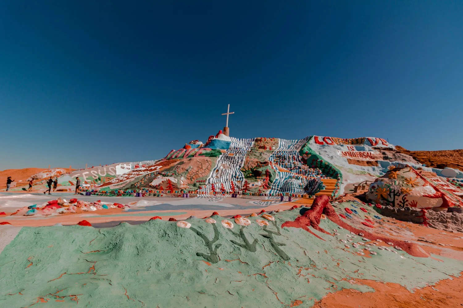
Salvation Mountain is Leonard Knights’ life work and homage to God in the middle of nowhere.
Colorful Dr. Seuss vibes dazzle Salvation Mountain out in Imperial County’s desert.
The biblical mountain was built by the late Leonard Knight who spent over 20 years building and painting the structure out of his pickup truck in the unforgiving desert.


The first hymn-covered hill he constructed actually collapsed after 4 years of work because it was built on sand.
Afterward, he carefully started over, saying it was God’s will for him to share these messages despite the obstacles. His handiwork demonstrates perseverance and dedication, reminding me of the Old Testament story of Noah’s Ark.
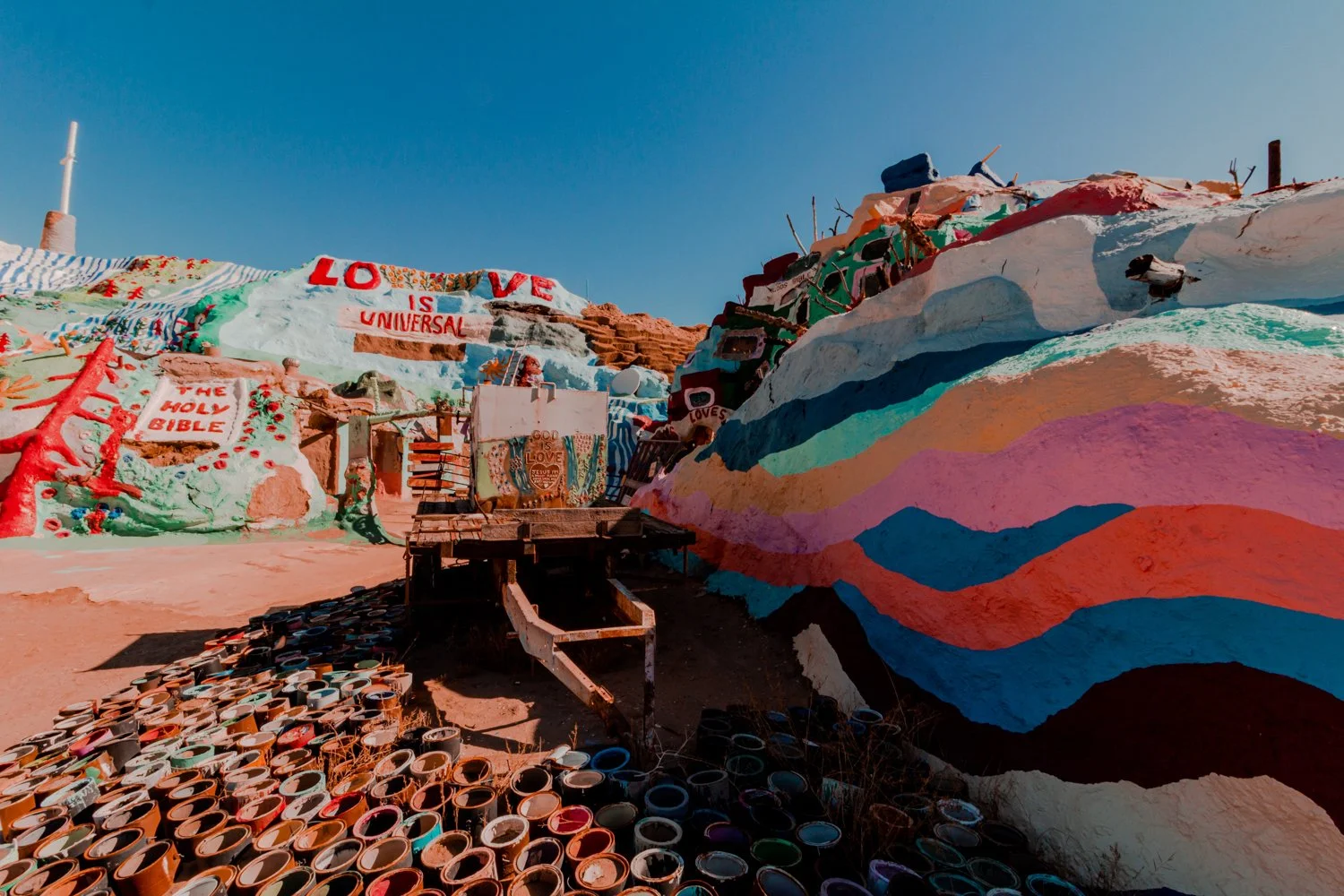
Lots and lots and lots of paint.
I’m thankful Leonard never gave up on his life’s work, as his writings of love and hope shine vividly today.
Note: Part of the hill was under construction and not fully open when we visited.
I admit it felt a bit uneasy to be stepping foot in the lawless land of Slab City for the first time.
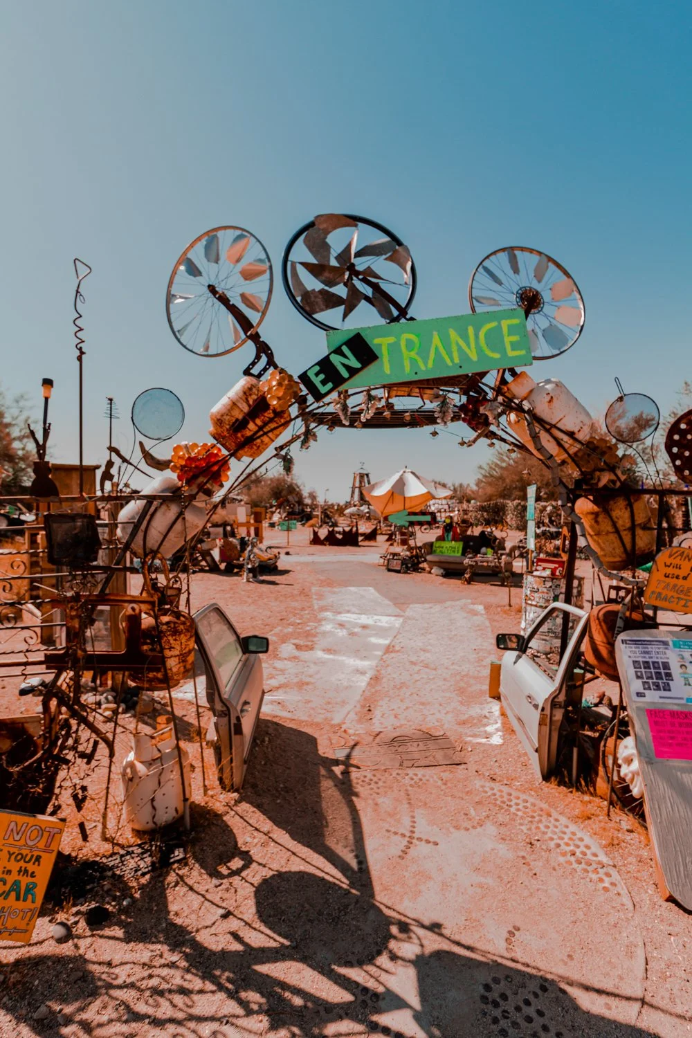
Visiting Slab City is a must on your Salton Sea itinerary.
Just a quick hop and a skip down the road from Salvation Mountain lies the unincorporated boondocks of Slab City, the modern day village where retirees, nomads and snowbirds have gathered for decades in the Southern California desert.
But the first thing we saw as we drove up the main road in our bright sedan eased our nervous qualms.

Everything is art in Slab City, home to the alternative souls.
We were welcomed by a young woman playing banjo on a couch near the main entrance to the community. Her platinum locks and puffy princess dress stood out from what looked like a crowd tailgating on the side of the road, or an RV park version of a neighborhood block party.
The town’s moniker refers to the concrete slabs that remain left over from a World War II military base, now inhabited by squatters.
I want what he’s having…
Striking. Resourceful. Beautiful.
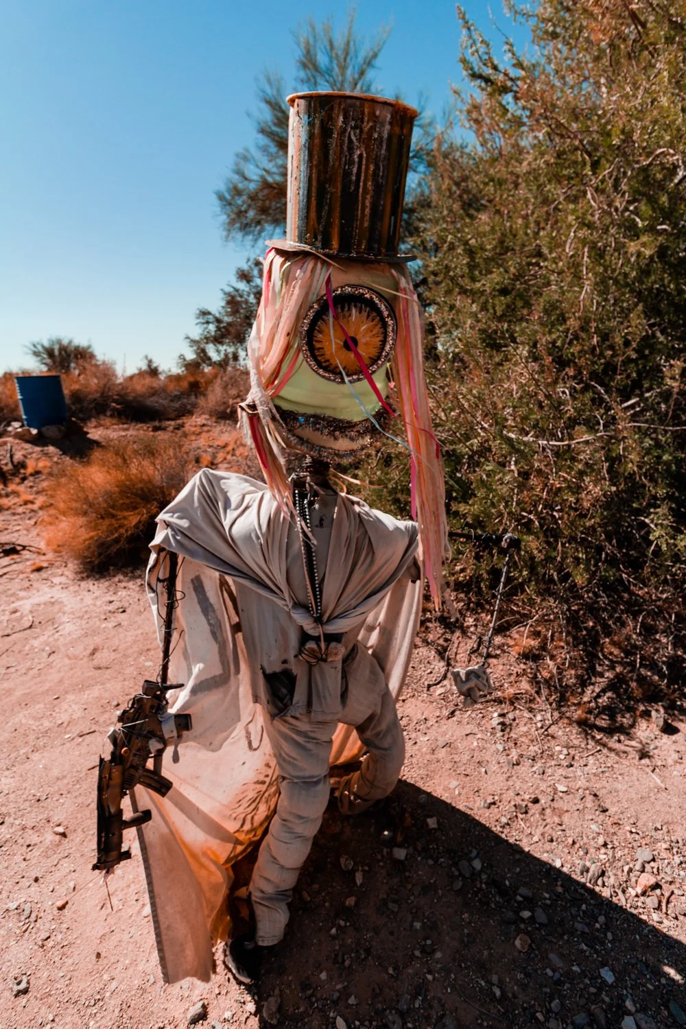
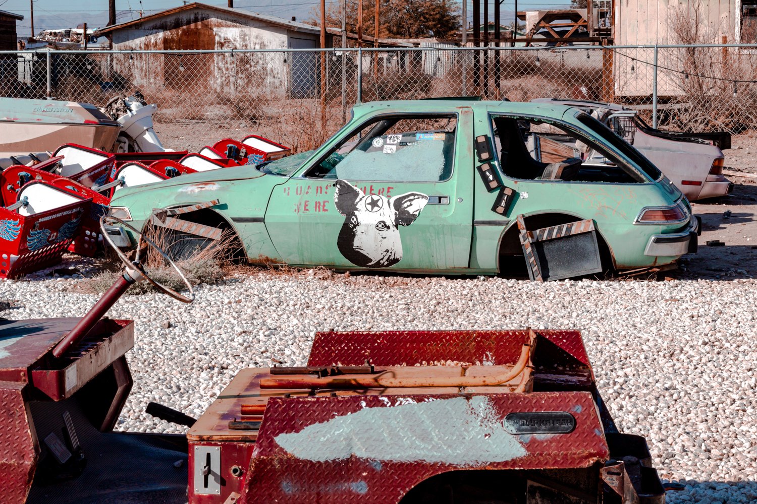
The ever-changing East Jesus exhibit on the edge of Slab City is a gallery of treasures crafted from another’s trash.
Old vehicles become furry creatures, televisions transform into blank canvases for hand-painted messages, and tourists’ forgotten water bottles hang together for an art piece.
Contrasting with the whimsical pieces, a Black Lives Matter section a la 2020 rendered me speechless. The last words from Black men and women before they were murdered by police both haunted and moved me.
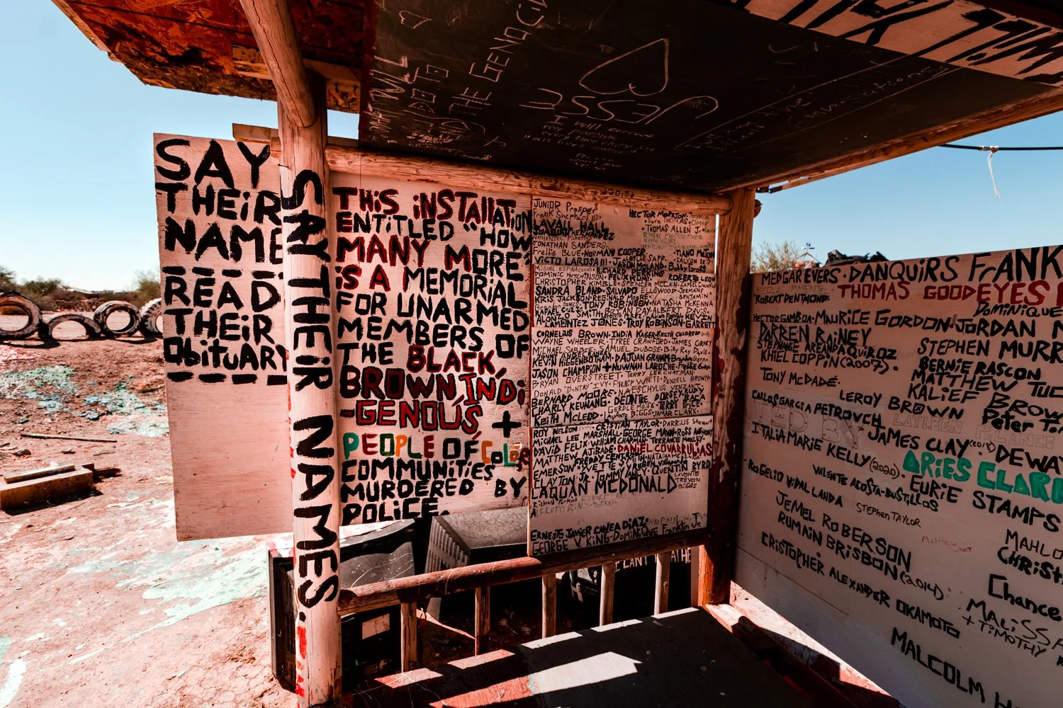
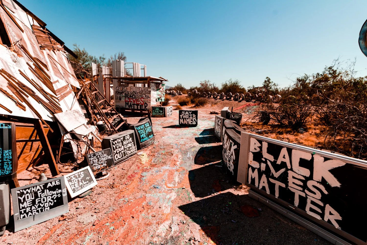

Honestly, viewing the Black Lives Matter exhibit was the most memorable things I did in the Salton Sea area.
Along the Salton Sea, lonely swings and shapely sculptures perch along toxic waters.
With no drainage, the sediment of surrounding sand oversalted the manmade sea, producing a deadly graveyard for fish and plants.
However, there are special nuances to the sea, despite the sulfuric smell.
Sunrises glow out of the water, something us Californians never experience on the Pacific Coast.
Antique furniture, doorways to nowhere, and anonymous transcripts left us smiling. I felt at home and at Burning Man at the same time.
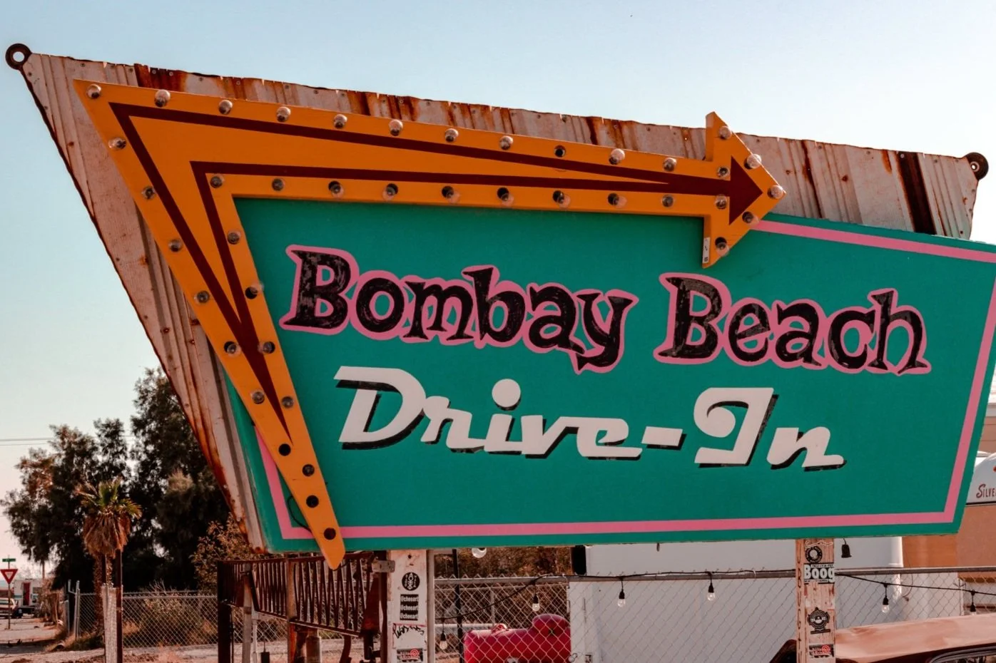
Salton Sea actually used to be swimmable. Bombay Beach, now a ghost town, brought celebrities in the 1950s like Frank Sinatra and the Beach Boys, and even offered fishing and boating.
After the sea turned toxic in the 1970s, the town emitted a post-apocalyptic energy, cluttered with remnants of what was once before.

Though most visitors we saw simply drove through without stopping, we strolled around the hot desert town to find anomalies like upside down airplanes, mannequin scarecrows and a lot of displaced items on roofs.
We stayed overnight at the Zig Zag House in Bombay Beach, thanks to our gracious host named Tao.
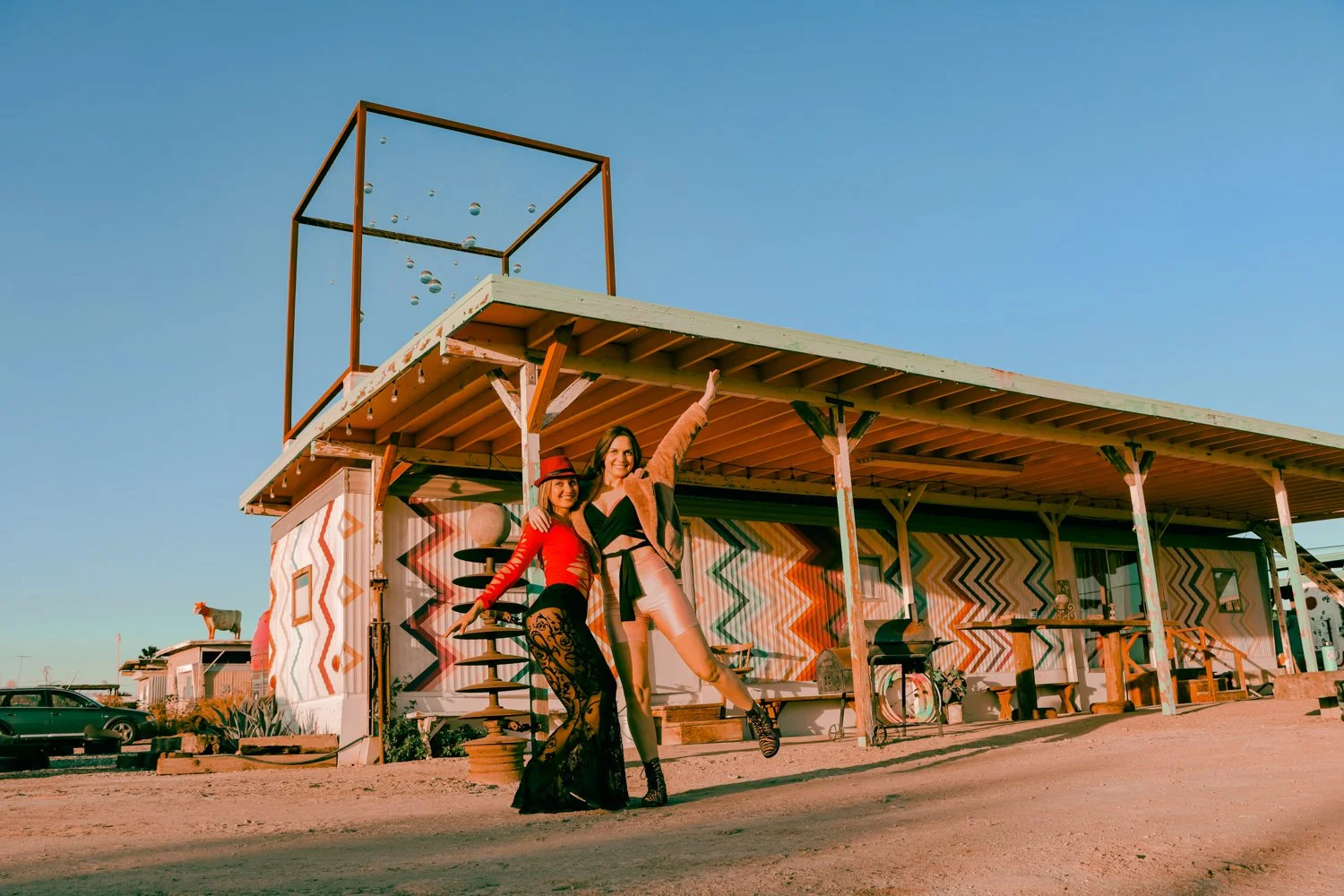
Photo by Kirsten Pastel
Apparently, it’s a Pinterest-made-popular house since tourists were getting out of their cars to take photos of the puzzling-patterned trailer during our stay.

We met individuals from all over who had come to take photos… including some of us!

I loved the charming red vibes inside the Zig Zag House, and all the enchanting elements of the exterior.

Is it a theater? A junkyard? Or a captivating art piece?
The Bombay Beach Drive-in left me with many questions.

I presume moviegoers left their vintage buggies a long time ago, and a new wave of artists decorated each car, mixing contemporary creations with nostalgia.
Either way, you’ll want to watch your step.
This doo-wop turned hipster town would not be complete without an array of abandoned buildings that any street photographer would salivate over.

The Bombay Beach Estates stand out, however, with the addition of the World’s Shittiest Museum.
Like a decrepit art house, the ‘museum’ showcases a crass theme in every room.

A putrid lime green room satirizes the phrase Cleanliness is Godliness with toilet brushes tantalizing the décor.

In other quarters, somber sayings sprayed on walls punch you in the gut with raw emotion.

In today’s days post-pandemic, this trip was a fantastic getaway for those interested in ghost towns or provoking art. All activities here were free, but you can donate with cash (or other treats) if you like at some of the exhibits.

The air out in Imperial County was eerily quiet at first, but grew peaceful as we stayed longer. This was probably for the best, considering social distancing.
While a bit risky heading out in the middle of nowhere, we met several kind folks who seemed like they sought to escape mainstream reality for a reason.

And the strangest sight of all? Waiting for that pink sun to rise out of the mysterious sea.

hi wolfette, i’m molly
Travel is a spiritual experience for me, especially when adventuring solo.
After visiting 6 continents on my own, I’ve dedicated this project to assisting other Lone Wolfettes on their journeys.
I hope my travel guides help you find the same joy, connection, and empowerment that exploring our planet has given me.
Excited about your visit to Sedona, Arizona but not sure how much time you need for all the adventurous hikes, which parks to visit, and what activities are worth doing?
I am going to share with you the absolutely perfect Sedona 3 day itinerary that includes the best of this southwest destination’s top highlights: red rocks, natural waters, and energy vortexes.

Grateful for the energy this magical, rustic, vibrant place has given me.
An oasis for hikers, Sedona lures in travelers who stay anywhere from 2 days to weeks, calling them in to wander new crevices and caves.
When I visited this green, red, and orange destination in the Fall for my birthday (October 3 - Libra baby!), I found that 3 days was the perfect amount of time to experience most of the mystic area.
If you have an extra day, I’ve included a bonus day 4 to visit the magnificent Grand Canyon, as it is only 2 hours away from Sedona.
Oh, and the friends I road tripped with are late sleepers (despite my wanting to get up early for heatwave hikes)… so if you want to take things slow, just know that this itinerary leaves you plenty of time to relax as well.

I’ll try not to give all the secrets away… just remember to keep the wilderness wild.
But, wait a minute.
What the heck is an energy vortex?
New age folks claim that these vortexes are specific points on the earth that emit strong energy and inspiration from underneath the red rock. There are four centers in Sedona that are thought to host energy vortexes: Bell Rock, Airport Mesa, Cathedral Rock, and Boynton Canyon.
Intrigued by the concept, yet skeptical of anything other than first-hand experience, we crafted a plan to find out. We would visit Sedona and enjoy the world-famous landscapes, whether these spiritual energy centers were real or not.
Additionally, one of the best things we did when planning was to include bodies of water in our itinerary to cool off from the heat after camping and trekking (and sweating) all day.
As a result, our blend of hikes, vortex views, and aquatic time created a perfectly balanced 3 days in Sedona.

Cooling off in the afternoon swimming holes is essential after a hot hike.
Cost: Midrange / Budget
Traveler Type: Any (Solo, couples, groups)
Days: 3 (plus option for a bonus day)
Interests: nature, hiking, mysticism
Transportation: car, walking

Your perfect Sedona 3 day itinerary begins on one of the most beautiful highways in the Southwest United States. (Scenic Byway 179).
Driving from California took us half a day, so we’ll call this Day 1. It’s best to arrive during daylight to soak in the stunning sights of Sedona’s scenic byway 179, so plan your road trip (or flight to Phoenix) accordingly.
You will pass the famous Chapel of the Holy Cross embedded in stone mountains as you head up north, so keep a look out!
Before you get to your first destination, there are a couple of things you should know.
First, most trails require a Red Rock parking pass for your car, which you can purchase at the visitor center or at most parking lots for $5 a day or $15 for the week.

The parking lot of Bell Rock Canyon was pretty empty in the sunny afternoon, even on a weekend.
Secondly, the least crowded time of day to hike surprisingly proved to be the afternoon. For once, sleeping in benefited us! By getting a slower start to the day, we avoided the swarms of morning folks on the trails. Additionally, by hiking in the afternoon we got to relish in the shade and sunsets, so the weather never grew overwhelmingly hot.
Lastly, before you hike anywhere, you should download the offline map of Sedona on maps.me. With no service on the trails, you don’t want to get lost in the heat, and it will help you navigate regardless. In this climate, bring more water than you think you will need and pack a hat, sunglasses, and sunscreen.
Distance: 4 miles
Location & Map: View on AllTrails
Welcome to your first vortex!


After a long drive makes you want to just jump out of the car and move around already, Bell Rock is the perfect hike to launch your hot, flaming rocket of an unforgettable desert trip.
Besides being claimed as an energy vortex, Bell Rock gives a stellar introduction to Sedona’s landscape. As you emerge from the highway, Bell Rock enchants the newly arrived explorer with vast previews of Eastern Sedona.
Climbing the looming face of the gargantuan rock stretches the views wider and wider, and you shrink smaller and smaller.
We reached Bell Rock via Big Park Loop, or you can take Courthouse Butte Loop trail, both ending up being 4 miles. However, the trails tapered off and became difficult to follow once you reach Bell Rock, so all the better to just carve your own way.
Both of these trails welcome all skill levels, remaining generally flat until the mountainous meet-and-greet.
So, did I feel the energy vortex?

Bell Rock is known by some to be an epicenter of strong vibrations and healing energy.
The ridiculous height of the red rock towering over us chilled my spine enough to make the baby hairs on my arm bubble up. And the higher you get, the quieter the air becomes. Mountain silence as we stand on top of the earth.
Yes, it could have just been the breeze of the five o clock purple sky that grazed my soul shield, rather than an energy source. It’s difficult to separate the hefty pulse of excitement from what the “zonies” call a natural resource.
Cave Springs Campground fills up quickly, so snag a reservation if you ever see one available!
Located a few miles north of downtown Sedona in Oak Creek Canyon, Cave Springs delights campers with a swimming hole, shaded forest ceilings, and much cooler temperatures than Sedona proper.

Happy to be in the shade at Cave Springs Campground.
We picked this campground for several reasons. First, it’s beautiful. Secondly, you can refresh in the water from the camp-side creek from the hiking trail that leads to different swimming areas.
Thirdly, when you wake up in the morning, you'll be super close to a wet attraction: Slides!
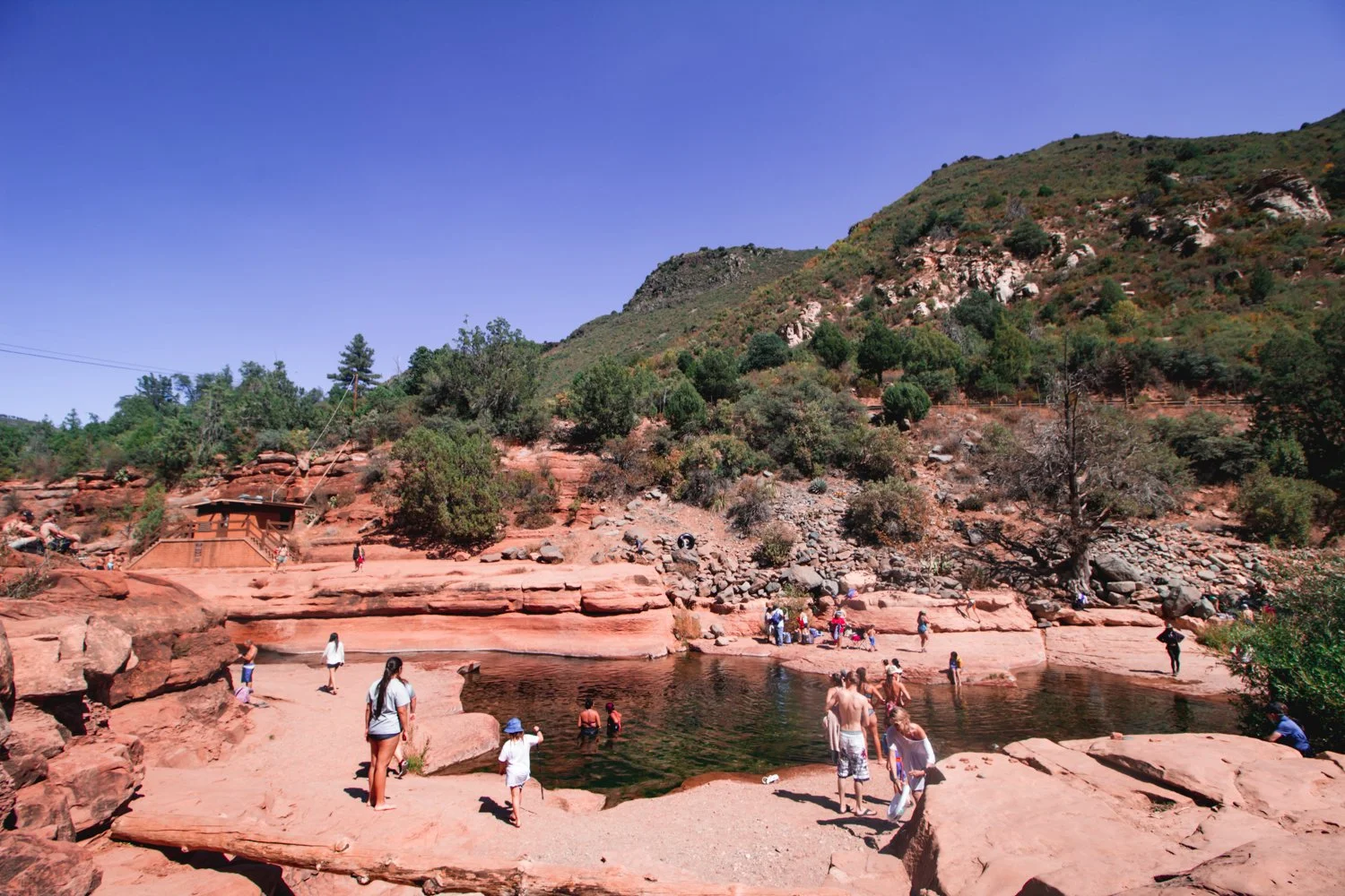
Location on Google Maps: https://g.page/slide-rock-state-park?share
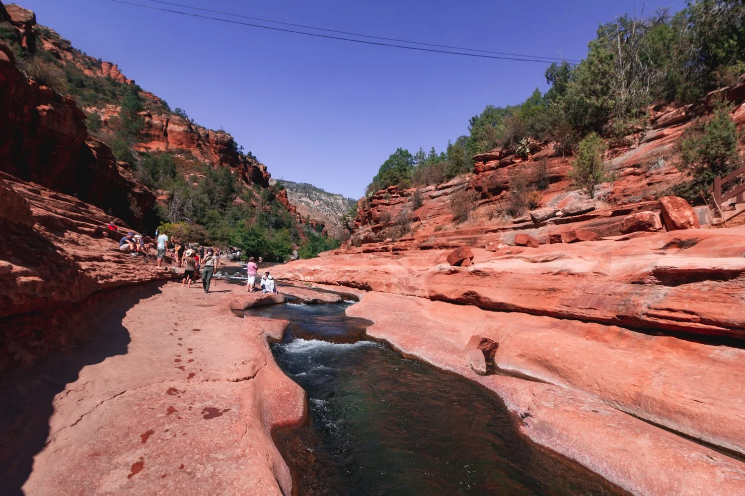
This water was almost freezing cold in Fall but so worth it and refreshing once you jumped in.
Slide down a natural water slide carved into the earth’s wavy crest at Slide Rock State Park!
Exuberant tourists and locals cheered each other on as we each took turns sliding down the bumpy ride.
The dramatic turns seemed a bit questionable at first but somehow safe overall (though I wouldn’t bring a baby on it).
Be warned, however - the ‘slide’ water flows freezing! Well, not completely freezing, but the temperature remains between 40 to 50 degrees Fahrenheit, depending on the time of year.
Besides swimming, jumping off ten foot rocks into the ice bath, and zooming down that erratic slide, you can also hike trails in the park and absorb historical markers.
Next time, I would visit Slide Rock State Park in the Spring instead of the Fall, when the water is full of rainwater, in order to facilitate a smoother glide down that slide.
Distance: 4 miles
Location & Map: View on AllTrails
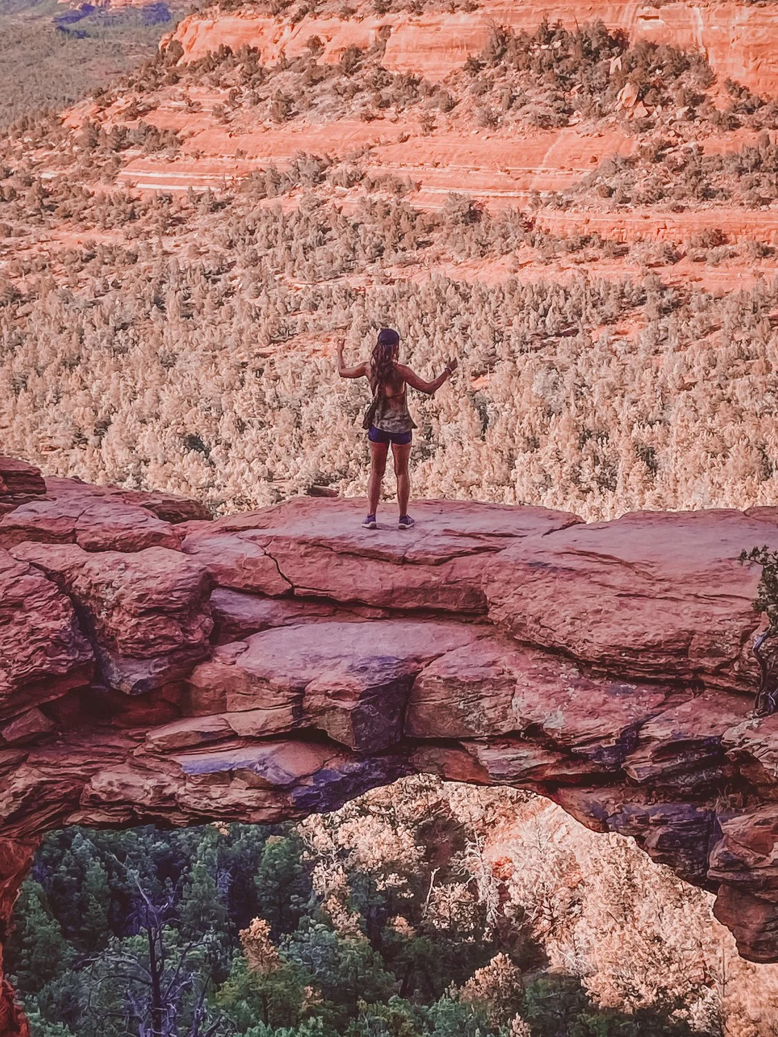
The ominous drop at Devil’s Bridge actually inspired my entire Sedona trip. Though I fear heights, the thrill of walking over that natural arch lured me in like a devil’s hand.
The 4-mile roundtrip hike gradually inclines at a steady pace, making Devil’s Bridge another approachable hike for almost anyone with sturdy shoes.
Sunset invited plenty of photo-philes like myself to line up for that Instagram-ready shot, but the wait was well worth it for the epic view.
Watch your step…


Sedona is a crossroads for travelers wandering through the southwest, resulting in a diverse offering of culinary bites and zen vendors, with a little upscale hipster flair.
In town, we found delectable eateries offer a range of cuisines from Tex Mex to fine dining steak and tapas establishments, as well as vegan varieties (after all, we are in hippie haven).
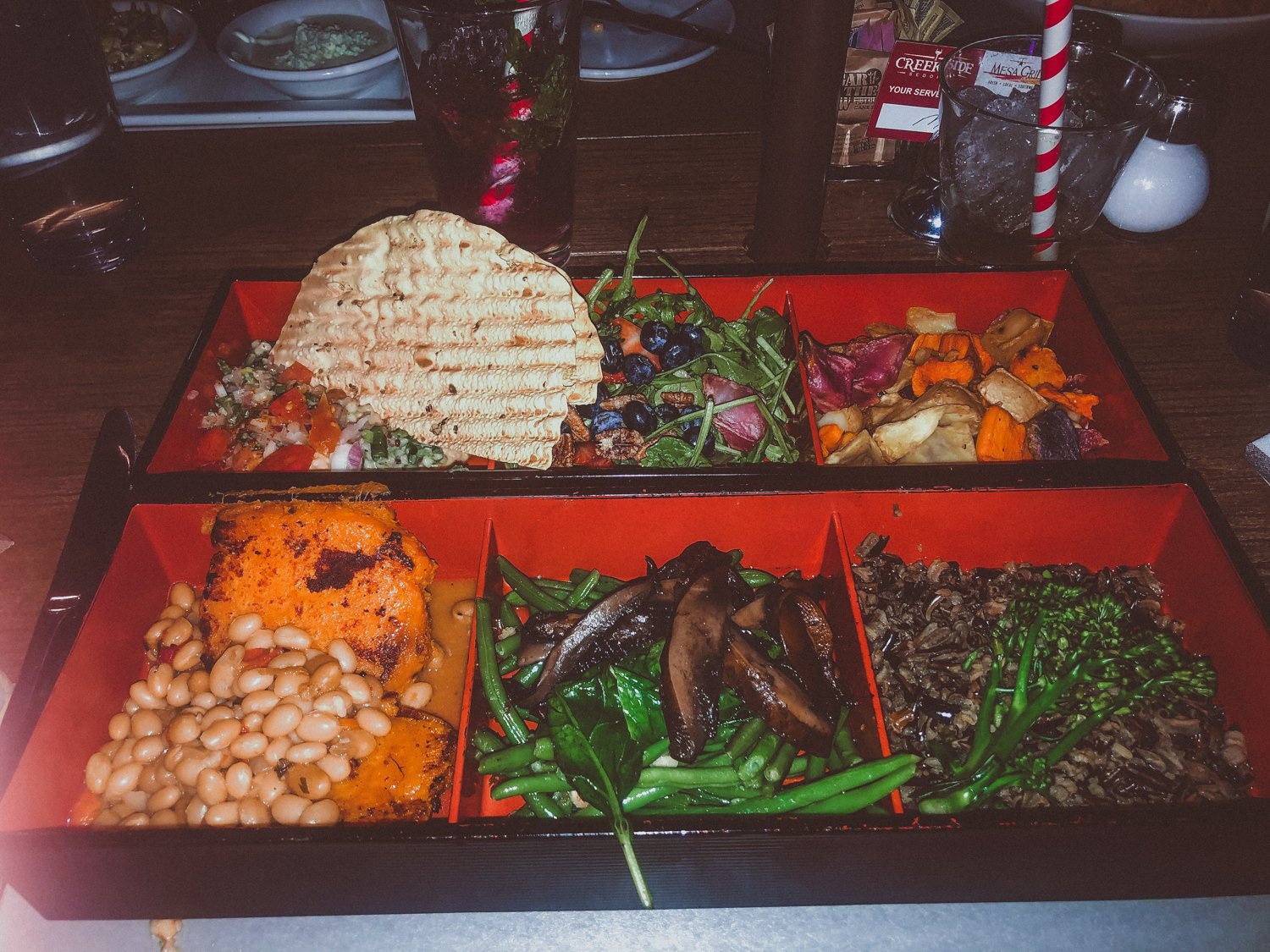
We tasted the town’s personality with a delicious dinner at Creekside American Bistro. I highly recommend their ahi tuna nachos and vegan bento box… as you can tell from my expression in the photos!
While waiting for a table, we graced the crystal shops and art galleries that sparkle along the plazas and shopping villages. Where else can you stand inside a human-sized singing bowl?


Distance: 1.2 miles
Location & Map: View on AllTrails
Welcome to your second vortex. Ready for a challenge?


Cathedral Rock raised my fear of heights to another level! Luckily, I survived the steep incline that ascends 700 feet in just about half a mile. Essentially, you are climbing in some parts.
Cathedral Rock’s energy vortex is located at the peak. Again, with all the people around it was hard to discern if my senses tingled from the adrenaline rush or a higher power, but it certainly felt like we were at the top of the heavens up there.
Location on Google Maps: https://goo.gl/maps/8jRv8bi3RwCkAJjN9


Looking for a place to cool off in the heat, we spent the rest of the afternoon at Grasshopper Point Swimming & Picnic Area, with red rock formations and shallow cool waters.
Luckily we found a spot in the small parking lot, so be prepared. As a second option, I would also like to try the Seven Sacred Pools hike which features caves and swimming as well.
Although splashing, hula hooping, and hiking back up the rocky trail left us winded, we still left time to enjoy the green horizon views with a grin.
Surprise! You’re driving to the Grand Canyon on night 3.
With Grand Canyon National Park residing a mere two hours away, we included a day to hike the famous world wonder.
The drive took less than 2 hours. We stayed at Grand Canyon Inn & Motel in Grand Canyon Junction so that we would wake up just 20 minutes from the national park. It was a safe, clean and most affordable option in the area.
If you have time to swing it, Sedona’s close proximity to the Grand Canyon makes the trip well worth the visit, even for folks like myself who have been several times before.
The Grand Canyon’s enormous route of trails tempts me to visit again and again (preferably not in the summer months, however).
We scuttled down the South Kaibab trail, taking one mile to reach Ooh Aah Point, one mile more to Cedar Ridge, and one mile to Skeleton Point, where unprepared hikers keel over from the treacherous altitude.
Obviously, going three miles down is always easier than stomping the three miles back up a furnace (I mean, canyon), so definitely be wary of your start time.
Sad but satisfied, that marks the end of the perfect Sedona 3 day itinerary in red rock country, plus a bonus day at the mother of all canyons.
As far as the spiritual energy, I concluded that I don’t need to visit a vortex to feel the ecstasy that excites my soul when camping and hiking. It powers my bones alone.
Stay safe, cool, and hydrated, and enjoy your spiritual travel.
hi wolfette, i’m molly
Travel is a spiritual experience for me, especially when adventuring solo.
After visiting 6 continents on my own, I’ve dedicated this project to assisting other Lone Wolfettes on their journeys.
I hope my travel guides help you find the same joy, connection, and empowerment that exploring our planet has given me.
Stand on the edge of the Earth, peering down at the crusted layers of core that peel back to reveal a deep canyon of rivers, trees, and multi-colored rock.
Ascend onto deformed shapes resembling goblins, castles, or backbones of a lurking beast.
Question your galactic surroundings as you squeeze through narrow slots of Mars-like walls.
Southern Utah is home to enormous stretches of natural treasures that make for a perfect road trip, all within a few hours driving distance of one another.

While droves of experienced trekkers swarm from around the world to hike Utah’s famous Zion National Park, this Southwest corner of the U.S. houses several other gorgeous Parks deserving of a visit.
If you are frequenting 3 or more national parks this year, you should purchase an annual national parks pass ($80) that gives you access to any national park in the country. For multiple state parks, Southern Utah maintains different passes, available upon arrival.
Following the route of our road trip, here are 6 epic national and state parks we conquered in Southern Utah:

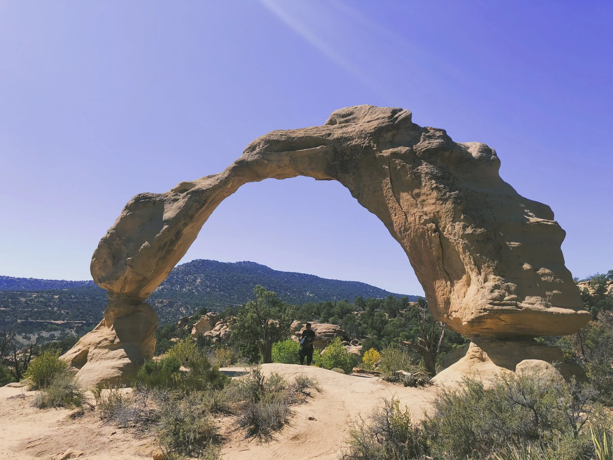
Arches National Park ended up being my favorite park, certainly worth the out-of-the-way excursion to the East side of Utah.
The famous Delicate Arch (featured in the article’s main photo) graces the Utah license plates for a reason. Each naturally-occurring arch in the park stands larger than life when you reach them up close.
Mellow, moderate, and difficult hikes reward visitors with hanging arches and glowing caverns.


We also witnessed petroglyphs throughout the park, finding them prevalent throughout Utah.
I recommend you linger in Arches after dusk, and even camp if you can. The animals meander at night, the people leave, but most of all, the starry experience lights up the silent magic of the park.

On the way to Canyonlands, we took an unexpected stop at Dead Horse Point State Park. The jolting name comes from the abrupt canyon drop-off where stampedes of horsed would unknowingly run over the side.
Thankfully, we didn’t fall down the canyon - but the panoramic views of the Colorado river astounded us.
The level walks around this small park brought relief from the daring adventures at the other parks, but still got us a bit lost, which is always fun.

Canyonlands’ name sounded like a theme park to me - and ultimately, the great heights, treacherous climbs, and hundreds of miles of trails fostered a similar happy-go-lucky experience.
This gargantuan park spans over 330,000 acres of land, with so much to do that I could return again and again. The park is divided into 4 districts: Island in the Sky (most approachable and popular), the Needles (farther hikes for backpackers), the Maze (most remote and inaccessible), and the rivers Green and Colorado.

When you reach the spout at the top of Whale Rock, you have to take a photo, right?
While the stunning Mesa Arch was closed, we stomped up Whale Rock, as well as a full-sun saunter along Murphy Point Trail (note to self: pack a parasol per person next time. Phew!).
In addition to hiking, Canyonlands offers river rafting, jeep tours and other backcountry excursions. You could easily spend a week there exploring.

We screeched to a halt as we passed the sign for Goblin Valley State Park, a name too enticing to pass by.
Mushroom-shaped hoodoos personify little goblins in this trippy valley as you head West through the bottom of the state.
Weather and the elements carved these figures into thick monsters, causing you to wonder if you are on a bad psychedelic trip. You can spend time trying to guess what the hoodoos resemble, as if you were pondering over clouds in the sky.

Be warned, the dry heat lingers warmer down in the valley, where there are no set hiking trails - just wander freely. In late June, we couldn’t stay longer than an hour in the valley while we sweltered, even with full bottles of water.
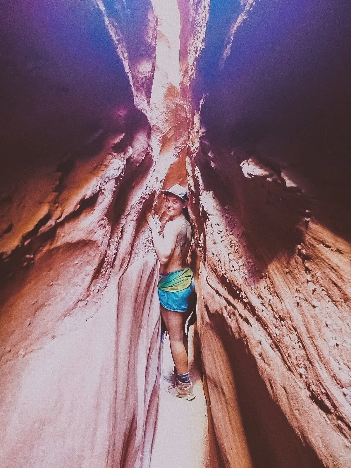
Pleasantly, we completed the hikes around the valley that highlighted Molly’s Castle (hey, that’s me!) and a surprisingly skinny slot canyon.

Encompassing over a million acres, we barely scratched the surface at Grand Staircase-Escalante National Monument. The staircase name details the row of plateaus from Bryce Canyon toward the Grand Canyon.
These photos featured are from the Spooky Slot Canyon, a hike so narrow that only smaller folks can squeeze through, without a backpack.
I learned rapidly that Utah hikes were not for the faint of heart, with parts of the hike you could seriously get stuck in (but yes, I still recommend it the challenge!).

The humongous swath of land in Escalante features waterfalls, gulches, slot canyons, and hundreds of miles of towering cliffs. In other words, the remote hiker can really get away from it all at the Grand Staircase, an epic place that deserves much more of my coverage.

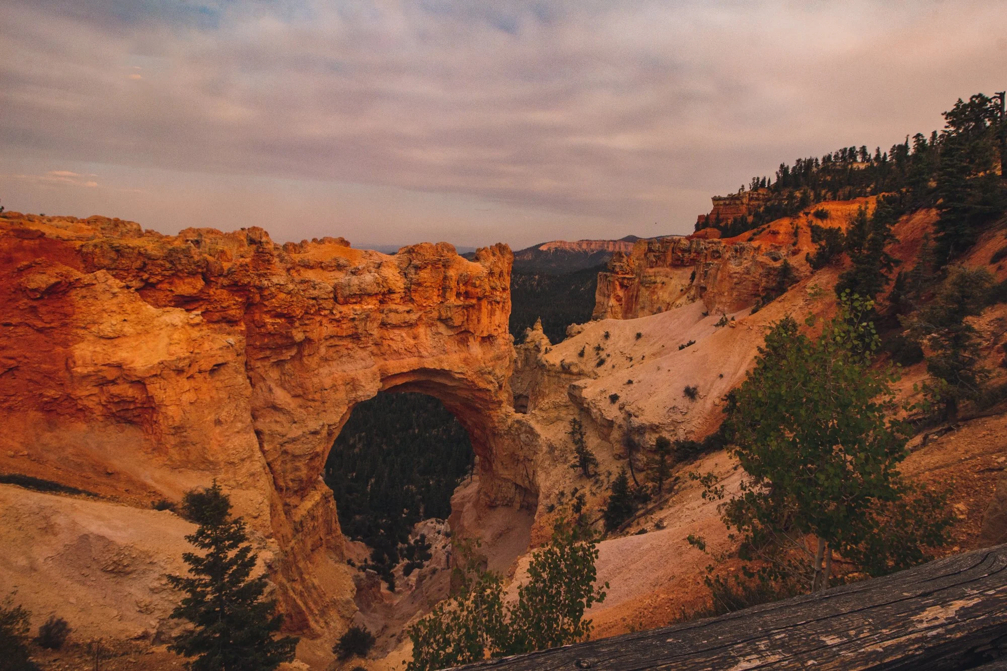
Bryce was so nice, I had to visit it twice! Check out my article on how to spend 1 day in Bryce Canyon for a full synopsis.
The main access road through Bryce Canyon National Park stretches just 18 miles, packing the most punch into a relatively “smaller” park, so you can see a lot of variation in a short amount of time.

Connect Queens Garden with Navajo Loop for a fantastic well-rounded hike that features redwoods, peek-a-boo windows, lavish structures, and a rainbow of whites, oranges, yellows and reds.
The colors of Bryce pop as bright as the pictures, and sunsets shine absolutely golden.
Happy travels!
When I decided to visit New Mexico,
I didn’t know the energy from ancient communities would move me to tears.

I didn’t know about the sapphire lakes with winds that test your strength of survival.

And I didn’t know about the valley rainbows that follow you daily, protruding out of majestic mountains and murky clouds.

While visiting the northwest side of the state in September 2020 during COVID-19, several parks and campground remain closed, so we tossed our plans in the trash and walked along the corn pollen road of growth and spontaneity.

Boondocking, or primitive camping, freed and liberated us. BLM lands remain open to the public for camping and day use, giving us a chance to socially distance while visiting the wonders of native lands.
Here are a few tales from the crypt: the best of our New Mexico road trip.

Our first stop on ancient grounds highlighted the beginning of our road trip in northern New Mexico.
Near the Four Corners, Chaco Canyon houses a national park thought to be a sacred gathering place – or something else anthropologists ponder.


Brick by brick, up to one story of hand-laid walls remain preserved, with the silence of the air only interrupted by the howl of the Southwest wind.
Powerful energy radiates from the enigmatic kivas and marvelous mesas at Chaco Culture National Historic Park.

The best thing to do in Chaco Canyon is to hike up through the park on trails that lead you around old pueblos among rolling hills. Step into another time and witness an up-close look at the kivas and holy places.

As we ascended up the hike towards Pueblo Alto, we were swept away by dramatic canyon views higher and higher.

The hikes are no joke at this high elevation, so be prepared for that solid New Mexico sun. It transformed me into a hot tomato!

While looking for a free campground, we stumbled upon a gift sent from angels.
Named for the neighboring tall summit, Angel Peak Campground offers free semi-primitive camping on BLM land up and up near the clouds.

After making our way up the windy road, we settled into a spot at around 4PM, no problem, and took a moment to soak in the views, and even do some painting!

Hiking along the trail during sunset hour toned down the evening as the red of the sky burned away.

After a few days of road tripping near the Four Corners, we realized we were only a half hour away from Colorado’s border – and what a better time to try some recreational CO herb?
Besides sampling legal weed, we dreamt of a lake where we could swim and stand up paddleboard – eager to savor the last days of sunny September weather before Colorado suddenly shifts to frosty Fall.


And our dreams came true. Right around the corner from the dispensary lies Lake Nighthorse, a sparkling pool of serenity.
Better yet, Monday and Wednesday at Lake Nighthorse is no wake day, meaning no jet skis or boats disturbed the flow of kayakers, paddleboarders, and other aquatic adventurers like ourselves – and Phatty, the furry Lhasa Apso!


Cox Canyon Arch stands on the border between Colorado and New Mexico, a short half-mile hike hidden amongst sanded boulders and spiked succulents.
Scramble up shifted rocks to the steep top, and respect this special land – there’s something about it I can’t quite put my finger on…

Ok, so I learned the hard way that paddling out to an island may take a lot longer than I thought – not to mention the way back in gusty cross winds!
I’m thankful the lifeguards at Navajo Lake told us to wear our life jackets, because this big, beautiful, blue being of water at Navajo Lake State Park took on a life of its own throughout the afternoon.
Whipping winds surprised my naïve SoCal plans and transformed a gingerly paddle into an intense hour-long race back to shore, but I would return in a heartbeat for the immense space and lush mountain backdrops.

Is it slinked or slunk? Either way, I felt like a sleuth as we investigated the compelling ruins in Aztec, New Mexico.

The name Aztec is a misnomer, because the site did not belong to Aztec people – instead, it was constructed by Southwest tribes referred to today as ‘Ancestral Puebloans’.

Some of these structures at the Aztec Ruins were rebuilt to give you a modern look at the great houses and ceremonial grounds. The doorways were tiny!

This energetic center is believed to an outside meeting grounds connected to the people of Chaco Canyon.

Braving that scary high and narrow road on top of Navajo Dam, we headed South to relish the state’s spicy staple sauce slopped on huevos rancheros or enchiladas.
Frankly, we ate famous New Mexico green chile so fast that I forgot to snap a photo. Forgive me, but at least now you know it’s certainly worth a try!

With several state parks closed to out-of-state visitors due to COVID-19, we decided a national park excursion was the way to go, while safely social distancing.
The silver lining of these closures appeared as an impromptu visit to White Sands National Park, the largest dune field of gypsum sand in the world.


The white sand felt soft as velvet, packed finely underneath our toes. The sky blazed a memorable sunset as we picnicked on what looked like a private, 275-square-mile mineral blanket of ‘beach’.

Every Route 66 road trip deserves a stop to an old trading post for souvenirs!
We stumbled upon a rustic shop where I found a handwoven dreamcatcher from a woman with sun spotted hands and strong energy…
…as well as a quirky highway-side gift shop where a little old lady had just baked a fresh batch of fudge that was so delicious, we regret not buying more to this day!
Well, fudge. Until next time, New Mexico!

Thanks to Anh Pham for contributing several photos to this article, and for eating green chile with me that knocked you off your feet… and to Phatty, the furry friend stuck with us.
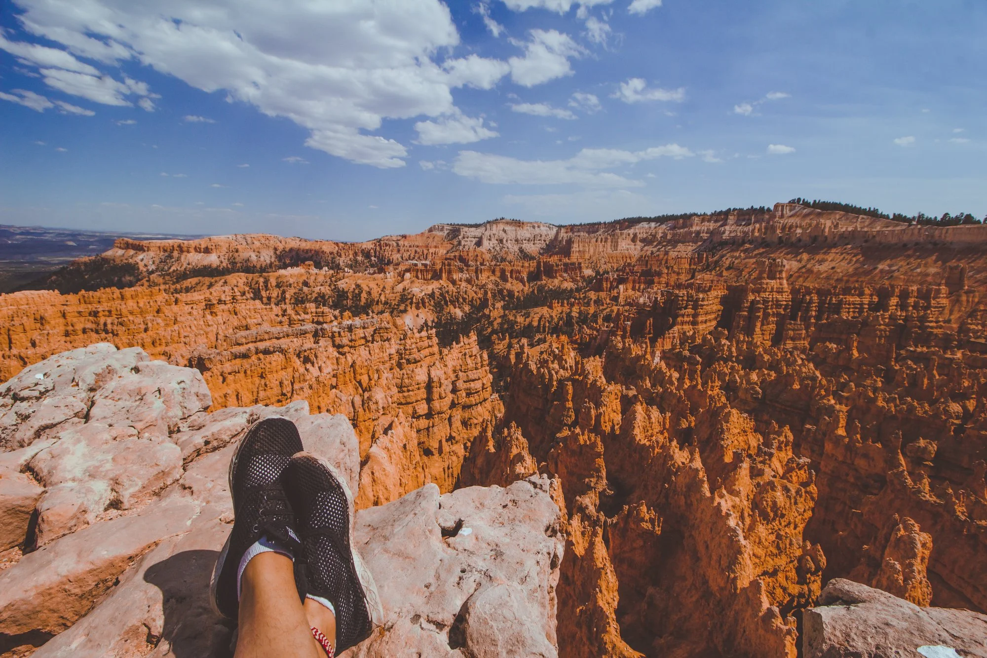
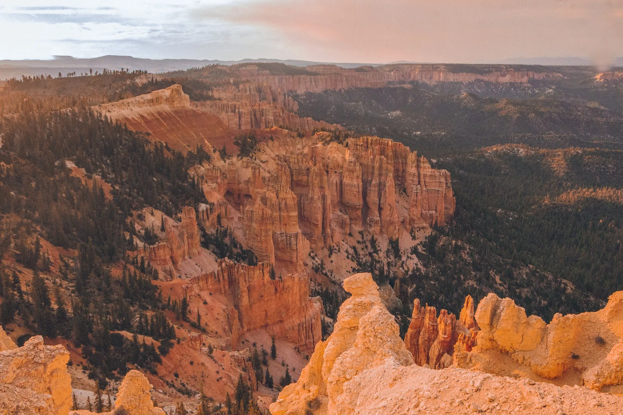
Rustic red beauty, gargantuan rock formations, and mysterious valleys can keep you trekking through the elusive Bryce Canyon for days.
However, unlike other national parks, this Southern Utah park is fairly compact and is accessible for travelers who only have a day to pass through, often before or after the neighboring Zion National Park.

We were able to take advantage of the nearly 9 PM sunset time in June and discovered the best way to spend one day in Bryce Canyon National Park in the Spring / Summer season. The views were stunning, colors struck a vibrant chord, and the golden hour saturated the skin and sky.
This spontaneous pit stop proved well worth the sunny day visit, though I will have to return again sometime in winter to experience the mystic icicles and snow-topped hoodoos, the eroded rock pillars that Bryce is famously abundant for.
Enjoy my guide on how to spend one day in Bryce Canyon National Park… and you don’t have to wake up at 6 AM to do it. We’re living life on mountain time now, baby!
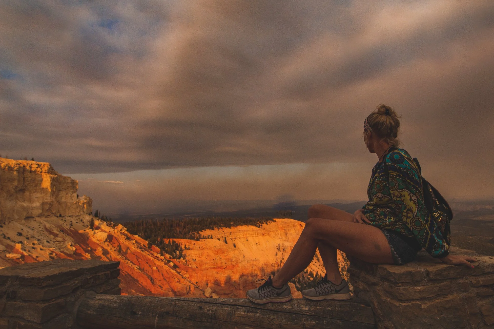
Immediately upon entering the park, you are greeted by Bryce Amphitheater, the orchestral valley with red, orange, and yellow hoodoos stretching as far as the eye can see.
Jump out and stroll along the Sunset to Sunrise trail for one mile of epic photo opportunities along the entire perimeter.
Potentially the most popular trail in Bryce Canyon, this 2.9-mile combination loop welcomes visitors embarking from Sunset Point to witness surreal changes in the earth’s landscape with striking caverns and monstrous structures that possess these distinctive names.

Highway 63 spans 18 miles of stunning viewpoints, the next being Inspiration Point and Bryce Point.
Look for the arches and windows formed by hoodoos that categorize each landscape unique.
Wildlife roams freely through the park, with dozens of species of bird, mammals, reptiles and amphibians. We spied mule deer, blue jays, ravens, lizards, squirrels and luckily, no Great Basin Rattlesnakes. If you are fortunate, you could even encounter porcupines, foxes, or even the endangered California Condor.

While this hike through the quiet backcountry is 4 miles, you can briefly cruise through the tree-lined trail for as long as you desire before turning around, to steal a taste of the terrain.
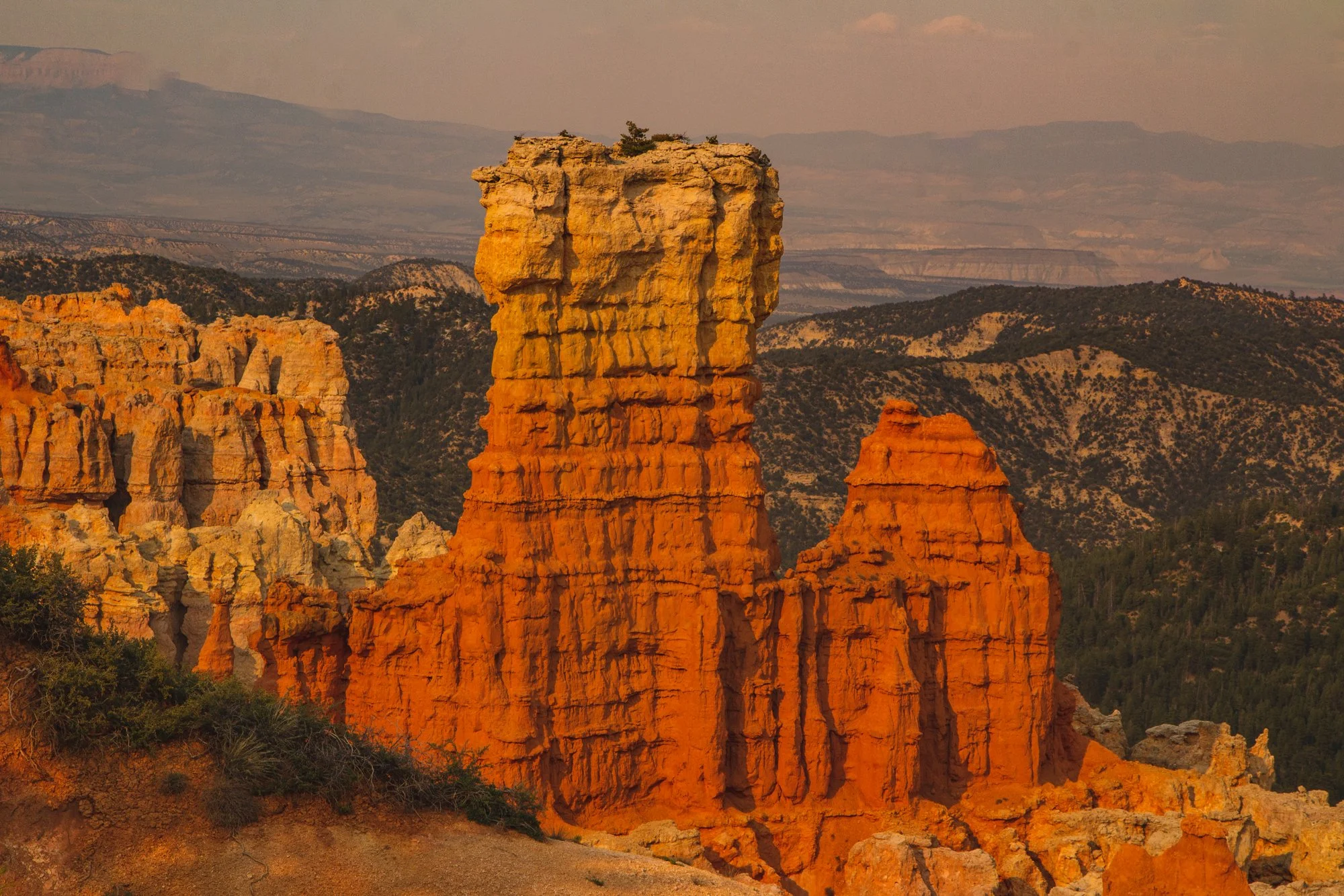
Natural Bridge became my favorite viewpoint of the entire day and features the attention-grabbing arch that steers your eyes into the valley. Agua Canyon is just a half mile down the road and full of imagery reminiscent of Dr. Seuss’ timeless book, Oh, the Places You’ll Go!…
Rainbow Point earns its name from the myriad of colors emitted from its topography: dark green trees mixed with whites, reds, and orange natural amphitheaters.
Our jaws dropped at the panoramic view before we moseyed through the 0.8 mile Bristlecone Loop, a partially shaded walk decorated with fir forests and bristlecone pines, like a winter wonder dream in the Summer.

End your excursion at Yovimpa Point, where the Grand Staircase peeks at you from underneath layers of rock. The Pink Cliffs, Grey Cliffs, and White Cliffs would make this point a more fitting name than Rainbow Point.
hi wolfette, i’m molly
Travel is a spiritual experience for me, especially when adventuring solo.
After visiting 6 continents on my own, I’ve dedicated this project to assisting other Lone Wolfettes on their journeys.
I hope my travel guides help you find the same joy, connection, and empowerment as exploring our planet has given me.
The treacherous climbs and descents absolutely terrified me, but they lead to the most beautiful beaches in the world on Nusa Penida, Indonesia.
You may have seen pictures of these remarkable locations on social media (that of course omit how ridiculous the hikes are), yet these spots prove even more epic in person.

Just eastern neighbors to Bali and not nearly as commercially developed, the small island of Nusa Penida has narrow roads full of character that speak stories. Many residents have stayed here their entire lives.
I zoomed past new houses being hand built (and probably stayed in one), but most of the charm of Nusa Penida is in its original untouched landscape that captivates photographers and people around the world.
Here are (more than) 6 unbelievable places to visit in Nusa Penida.

Broken Beach
Broken Beach and Angel’s Billabong are located right next to each other on the coastal cliffs.
You can walk from one stunning beauty to the other within five minutes and take the coveted selfie or fifty. Both carved out treasures are just as gorgeous in person and worth a brief visit, but you cannot swim or walk down to either beach.

Be careful at Angel’s Billabong, however, as several tourists have tragically passed away from standing too close to the edge trying to get a risky photo right before dangerous waves came crashing on to the shoreline.

While you can’t actually spot 1,000 islands, you are standing on a mini island yourself as you look out to the vast blue and turquoise waters that surround you with floating cliffs.
Thousand Islands Viewpoint will be your first workout with 10 minutes of steep steps up the mountain on the way back. You can pay to sit in those cute swings or cabanas for a photo op, but you don’t need it - the view is already incredible.


The wildest motorbike ride down into the forest led to Tembeling Beach and Forest, where several jewels shine hidden under the shaded foliage of the mountain.
The first gem is an emerald pool where devils can dare to jump from various levels into the deep. I only jumped off the lowest level, about 12 feet, scared to my wits. So worth it!

After cooling off in the pool, make your way down stone steps to a cave full of mysteriously stacked rocks, a natural rock infinity pool, and the beach.
All the way on less traveled east side of Nusa Penida lies the precious coasts of Diamond Beach and Atuh Beach, situated on opposite sides of a cliff.


Laced between the two beaches, it seriously feels like you are standing on the edge of the earth.
Atuh beach felt shallow and shelled with eateries and lounge chairs, while Diamond Beach hid behind sloshed choppy waves and shrouded cliff walls.

Though the days I visited burst dark clouds and thunderstorms since March deemed the end of the rainy season, each beach blew my mind with the natural colors and gorgeous shape of the earth.
The steepest hike of all 6 on this list, the 45 minute way down to Kelingking Beach starts out chill, and gets sketchy really fast. My heart raced as the jagged gravel stairs began to sprawl straight down.


Despite the heights, the picturesque waters truly glimmer aqua and dazzle deep blue. Kelingking resembles a tyrannosaurus rex floating heavenly between sky and water.

The driver that dropped me off made me promise I would not swim in the water because the current was too dangerous. He wasn’t kidding - the aggressive waves roared high and banged on to the shore sharp and strong. I had to hold on to my suit just standing on the shore…

Not my photo - I was too busy scuba diving for only the second time! Try Karma Diving in Nusa Penida.
A last minute decision to splurge on scuba diving with 9 foot manta rays proved to be the unexpected highlight of the entire trip - and well worth the expense, even for a backpacker.
You don’t need a diver’s certification to witness these majestic beings playing 40 feet down in the underwater jungle. Plunging so close to a dozen manta rays at Manta Point flipped my world upside down, leaving this unbelievable natural wonder the best thing to do in Nusa Penida.
From the West to the East… gorgeous views and dangerous waters categorized a stormy, thrilling excursion in Nusa Penida.
One hundred people surrounded me in the dark, but the only sound I could hear was that of my own breath.
Suddenly, a low voice swam through the thick silence and saturated all four corners of the open-air forest monastery where we sat in stillness:
“Right now, there is nothing you have to do or think about.”
The Thai monk’s mellow tone echoed throughout the wall-less Dharma Hall towards the ears of dozens of visitors and volunteers from around the world. I would hear his heavenly hum over the speaker every night but could only ever imagine the all-knowing expression that resided with it, since we kept our eyes closed throughout the routine.
“All you have to do…” he would continue with a lingering pause, “is focus on your breathing.”
As I prepared my breath to begin a forty-minute silent meditation, I savored the taste of the moment. I felt grateful to be in a special place, at none other than Northern Thailand’s Wat Pa Tam Wua Forest Monastery (abbreviated as Wat Tam Wua), absorbing the precious Theravadan Buddhist teachings from six monks.
At Wat Tam Wua, visitors are welcome to stay for up to ten days to practice meditation in a beautiful forest setting comprised of rainbow-colored trees, streams, hidden caves and mountains. The monastery runs solely off of donations from visitors and organizations. Volunteers facilitate the space, organize activities, and provide visitors with accommodations plus two vegetarian meals a day.

Though I was a foreigner without a Buddhist upbringing, I felt completely comfortable during my week-long stay at Wat Tam Wua, as they welcome anyone with open arms who aspires to learn about Buddhism, meditation, or simply “become a more mindful, focused and happy human being,” as their website explains. Check, check, check for me.
After hearing about the life-changing retreat from my hostel roommate who had attended, I researched Wat Tam Wua and concluded it was a must-do experience that aligned with my solo trip goals. Why do we travel anyway, if not to become better people?
My mind and body dueled and danced with each other during our thrice daily meditations in the monastery Dharma Hall. I sat in a white plastic chair (white was for women, blue for men) in the back of the holy structure that consisted of an enormous flat slabbed ceiling supported by wooden beams and glossed with ocher-brown tile floors, all encircled by forest views.

Most students plopped down on the moss green pillows in the traditional way with one leg bent over the other while meditating, but I resorted to the chair after finding this cross-legged position too difficult to hold for such long periods of time (about five hours a day).
In the daytime, the structure’s ceiling provided shade from the scorching Thai sun, as the monastery is located near Mae Hong Son near the border of Myanmar. In the evening, the whining mosquitos joined us for meditation.

It is quite a magical feeling to close your eyes on a purple-permed night in the middle of the forest across the world, resounding in the silent presence of the sacred and the studious, with all one hundred beings inhaling and exhaling at the same vibration.
The spiritual road is full of twists and turns. I hopped into a minivan leaving Pai’s hippie town that swerved through wavy mountains for one hour before the van driver halted to a sudden stop, dumping me in the woods of Mae Hong Son.
Another rider also got off the van to make the half mile walk to the entrance. She seemed less eager to chit-chat than me, which I didn’t take offense to since we were heading to a mecca for spiritual growth, not to make friends. Plus, I knew some visitors to Wat Tam Wua choose to remain silent during their stay (you can put on a Silent pin at any time), though not required.

What struck me first were two enormous golden mountains looming above like gods looking down over us, massively disproportionate to the rest of the landscape. They were greeters beckoning us in the right direction.
What would this spur-of-the-moment visit bring? What would I learn from the monks? These questions captivated me.
Finally, the trees parted to reveal an arched entrance above a wide sand road leading towards a village of huts by the river. We had arrived.

Two friendly monks in orange robes spotted our lost faces and waved us down to point us in the direction of the reception. I was pleased we were already able to speak with the monks casually, because as women we must keep our distance out of respect.
On that note, the volunteer checking me in did mention that women must sit in the back half of the main hall for all lessons and meditations, far from the speakers. We also had to walk behind the men during walking meditation. The reasoning was “to not have any distractions from meditation,” which you can make your own conclusions about. Later, these gender rules ended up being a bit inconvenient as the lessons often started before the women returned from walking meditation. However, I didn’t let this damper my experience and I was thankful to be able to visit the monastery at all.

The kind-hearted volunteer explained a few other rules essential to showing respect. Do not sit with your feet pointing towards Buddha; do not hug your knees into your chest when sitting (this implies boredom); all visitors must wear white clothes (these are provided if you have none); yoga is not allowed outside your kuti (poses can be provocative); be sure to arrive early to all activities.
Most importantly, all spiritual activities are mandatory, from 6:30 AM to 8:00 PM.
After checking in, I plucked a mat, blanket, and pillow along with the white uniform from the laundry shed and trotted towards the dormitory, since all the private kutis were full.

Photo by Catalina Koe
The dorm was one large room with a screen door for insects and a creaky wooden floor that could probably fit about forty mats. During my stay, the greatest amount of people sleeping in the room at a time was near thirty.
I tossed my pack down and quickly changed into the loose lavender-tinted-white pair of sweatpants and unisex V-neck blouse, almost resembling scrubs, ready to jolt downstairs and arrive early to the mid-day food offering to the monks.
My quiet mate from the van was slugging into the dorm as I leapt out the door. “You look like a nurse,” she smirked at me.
Our daily schedule consisted as follows, with mandatory activities in bold:
05:00 Morning meditation in your kuti.
06:30 Rice offering to the monks.
07:00 Breakfast.
08:00 Morning Dharma talk, and meditation class.
10:30 Food offering to the monks.
11:00 Lunch.
13:00 Afternoon Dharma talk and meditation class.
16:00 Cleaning the area and helping in the monastery.
17:00 Free time.
18:00 Evening Chanting, meditation and Dharma talk.
20:00 Meditation on your own, or have tea, coffee, hot chocolate & relax.
22:00 Rest time.
Every morning at dawn, we knelt in darkness to participate in the age-old tradition of offering rice to the monks. Each monk would hold an alms bowl while sauntering down the line of kneeling students, pausing in front of each student who would then scoop a spoonful of rice into the bowl. This was the breakfast offering, as monks only eat and drink what is given to them. Afterwards, a volunteers would bring the monks the rest of their meal to accompany the rice.

Photo by Catalina Koe
For the lunch offering, the final meal of the day, the process was slightly different. The female students would present the various dishes to the abbot (the head monk), bowing before him and raising the soups and salads and vegetable-potato-rice-filled dishes in the air before placing them down in front of him. The abbot would pick the dishes up with a receiving cloth (as to form a barrier between what the women had touched) and serve himself the food before passing on each dish to the male students that could offer them freely to the other monks.

The jolly light-eyed abbot would always make silly remarks that cracked me up, dissolving any seriousness at the monastery. He would laugh at his own jokes, too. For example, instead of instructing us plainly not to visit the dorms of the opposite gender, he would instead say “Tonight… no Thai massage!”. When recounting the story of a student who was afraid of a snake, he would acquire a high-pitched squeal, giggling as he mimicked the student: “Help me! Don’t kill me Mr. Snake!” as we all buzzed with chuckles.
For the lay-person meals (the students and volunteers), we would eat the same foods that the monks ate after they were served. We lined up for buffet-style breakfast and lunch, the latter around 11AM.
Having our final meal at normal “brunch” hours was not as big of a problem as you would imagine, given that we were rising and going to bed early. However, after the third ay I succumbed to my cravings and purchased snacks at the small store at Wat Tam Wua that sold items like cup of noodles, chips, some fruit, and sweets.

Why didn’t we eat dinner? From the Buddhist books I read at the monastery such as Ajahn Sumedho’s anthologies, they explain that while us lay people often surround our days around desirable foods and celebrate feasts, monks eat consciously as a utility. By only eating one or two simple meals a day, this limits food or other pleasures from becoming a priority over spirituality.
The dining area was split into two sections: silent and non-silent tables. Even though I chose not to wear a silent pin, as to have the freedom to speak if I wanted to connect with people, I still found myself sitting at the silent tables every meal, reflecting.
What some people found tiring ended up being one of my favorite activities: evening chanting. We chanted uplifting credos in Pali, Thai, and English for forty minutes, and although I only understood the English, I treated the chants like songs, and belted them out loudly. After all, it was our only music!

Voluntary cleaning usually consisted of raking leaves or sweeping around the monastery, although we were encouraged to help out at all times, from preparing food in the kitchen to washing dishes to tidying up the common areas. The hour gave me a chance to get some light exercise and chat with other students to find out how their meditation experiences were going. I even got a rare chance to speak one-on-one with the abbot (though we just made small talk).
“Feel each part of the body. It is not your body. It is the body,” the monks instructed us during sitting meditation. “Feel!”
The monks detailed the distinction between the soul and the mind and the body — between observing and thinking and feeling. This body is merely a vessel for us to experience during this lifetime; not the same as the soul of our being.

“Notice the mind thinking. It is not your mind. It is the mind.”
We shall disassociate with the mind as self. We notice the mind’s mortal thoughts without judgment, like watching a cloud pass by. We do not try to stop or repress the thoughts, as they will disappear on their own once we are observant.
Our soul is the knower.
These acknowledgments laid the foundations for our meditation practice.
Each meditation session consisted of walking, sitting and lying down meditations.
Walking meditation? I always thought meditation was about sitting still.

Photo by Catalina Koe
We would shuffle slowly in a single file line through the forest, the utmost serene setting. One monk would lead the line, meticulously stepping his right heel down like molasses, followed by the ball of the foot, then toes, chanting the mantra “Bud” in his head. Then, the same thing on the left side, except chanting “Dho”. You can imagine how slow we were walking.
“Bud dho” means “the one who knows,” as we become the knower: aware of our thoughts, separate from the mind, rather than letting our thoughts run like a wild horse.
The point of each calculated step was to remain focused on one object, such as the soles of your feet, the inhale and exhale of your breath, or the mantra “Bud-Dho”. This is the essence of Samatha meditation.


Once we master Samatha, we may move into Vipassana meditation to reach a greater wisdom. Vipassana meditation involves moving the object of concentration into the background (i.e. your breath) and noticing how the mind wanders towards or away from that object, allowing the thoughts to become the foreground. Thus, in Vipassana meditation we notice both the object and the mind at the same time.
It was challenging to stay focused while woodlands of wonder preceded us.
We strolled by gorgeous gold and purple flower petals, the sparkling river, autumn-tinted leaves, mysterious caves, and a cute Chow-mixed dog named “Bui Dog” that would follow us around the monastery. I still think his name should be “Bud-Dhog”.

After almost an hour of walking meditation, we washed our feet and sunk back into a chair or cushion in the main hall to practice sitting meditation using the same fundamentals for another forty minutes. Finally, we reclined on the floor for a fifteen minute lying down meditation.
We repeated this triad in the morning and afternoon, with the evening session solely consisting of the sitting meditation.
It may sound like a lot of meditation for the beginner, but the way the sessions were broken up gave the day structure and made sense.
Despite a week of studies, the greatest takeaway I left with was that truly understanding meditation comes from practice.
Each day of practice grew easier to focus and calm the mind. While the first day or two was challenging – to sit for hours, to stay present, and to find stillness – my experience transformed into pure bliss after breaking the ice.
Still, I felt quite lost at times. Am I doing the meditation correctly? My mind wanders less, but I don’t feel particularly wonderful, or like I am accomplishing anything.

I decided to borrow some books on Buddhism from the monastery library to aid my practice and fill in the blanks, and ended up reading five books during my stay. The books written by bhikkus and scholars explained concepts in depth, from the fundamental truths of Buddhism all the way to modern applications today, answering several questions I had. Here are just a few that may be useful to your daily life:
Working all day and doing one meditation at night is not likely going to be able to cure all our learned mental patterns. Instead, focus on co-existing with these busy mental states throughout the day. Be kind and patient and aware. In other words, apply the constant practice of non-judging, non-attached loving kindness throughout the day to remain in a neutral state.
Our arising thoughts and feelings are normal and should not be shut out, whether we think of them as ‘good’ or ‘bad’. Emotions are mortal states that we cannot repress. We simply absolve them by acknowledging them, which results in their naturally passing. Meditation allows us to remain neutral towards these emotions. In Buddhism, there are no mental offenses, no sins for certain thoughts, so long as we do not act upon them.

We cannot control the world around us, and we suffer when we expect the world to bend to our satisfaction. Oftentimes, we blame society or our upbringing or other folks for our problems. It is true that other people behave in ways that are inappropriate, however we are still responsible for our own reactions and expectations. Their actions result in their own karma. The good news for us is that when we stop clinging to an outcome, we are able to let go and accept the world as is — freeing us from desire and suffering.
We can still be productive individuals and achieve purpose in our lives, without heedless desires. This comes from knowing things as they really are, through mindfulness. When we observe with an uncontaminated mind, we achieve clarity on what we are here to do, without intrusive desires or clouded judgment. For example, Buddha was free of desire but still remained a productive teacher. He did not become one in order to be a famous person, or to earn lots of money, or to find a wife — but because it was his calling. Neutrality through meditation allows us to make guided choices to understand what we need to do and what we need not to do.
This unique week that I had the privilege to spend at Wat Pa Tam Wua Forest Monastery in Thailand was nothing like I expected but became everything I needed. I am eternally grateful to the extremely patient monks that dedicate their life to teaching others, answering all our outlandish questions in multiple languages, and giving us the tools for a lifetime. I thank the volunteers who pour their hearts into the monastery yet collect their plate of food last.

On the last day, I left my donation and crammed with ten others into the bed of a rustic metal truck that skirted out the cream-colored arched entryway. I looked back at the gods on the golden mountains as the sunny waters whispered to me, goodbye.
An assortment of Spring memories not already pictured. Click each preview to view the full image.
Come gather around the bonfire, as I am going to tell you a story about a tiny island that lies in the South Seas of the Pacific Ocean, a magical place I will always remember: Gili Air.
A small village with a big heart, Gili Air is an enigma. To give you an idea of how absolutely miniscule the island is - it is undetectable on a map of Indonesia, and you can stroll around the entire oblong perimeter in under two hours. No cars traverse the narrow dirt roads; instead, people get around by foot or bicycle. You will cross paths with a few horse and buggies, but these are primarily a tourist attraction.
“Why are you going to Gili Air?” fellow travelers would ask me, bewildered. Their curiosity stems from the notion that the island of Gili T is the bigger and better destination, known for its wild parties and highly developed area. Though it may be true that Gili T leads the pack in tourism – heck, Gili Air did not even have ATMs until a couple years ago – my response to the inquirers is simple: I like to take the path less traveled by.
I will reveal why this tropical key is one of the best-kept-secrets – from psychedelic nights to emotional experiences in an oasis hidden from the world – but first, some brief background.


Gili Air is one of three major Gili Islands along with Gili T (short for Trawangan) and Gili Meno. Gili means “small island” in Sasak language and Air means “water”. Many travelers are unaware there are actually more gilis, about 26 in total, but most of these are too small to be habitable. The main trio rests next to the larger neighboring land of Lombok, a 10-minute boat ride away across teal waters, where many local workers commute from each day. Eager tourists usually ferry from Bali, about two hours west on the high-speed boat.
While I felt like a nosy tourist snapping photos in Indonesian’s gorgeous destinations of Bali and Nusa Penida (how could you not?), the moment I arrived in Gili Air and stepped knee-deep in clear turquoise saltwater to deboard the boat, I was immediately greeted with a warm welcome – and would soon become treated like family.

With only around a couple thousand people on the island at a time, there are less people on Gili Air than there were students at my high school. But unlike memories of public high school in Los Angeles, the people on Gili Air are warm, friendly and kind (just being real here).
You begin to see the same people around on the island, and if you are an open book, you get to know everyone on a first-name basis. I’m talking about the workers, whether they are restaurant owners, tour operators, shop clerks, beach club bartenders… they all greeted me with genuine smiles and conversations that ran deeper than the basic questions or feigned interest you often contend with while traveling in Asia. Honestly, most locals seemed just as interested to meet you as you were to meet them.


If the song “Don’t Worry, Be Happy” was a place, Gili Air would be it. Not only did I hear that iconic song a lot… but the dozens of folks I met during my stay were chiller than chill. There are plenty of exciting activities to do in the gilis, which I’ll get into later, but the vibes are mellow on Gili Air, to the point where I feel like I could live there. Everyone is living the slow life.
Literally.
“Slow down, woman!” my new friend “G” playfully barked at me the first night I arrived. I had been frantically asking too many questions, after discovering I was lucky enough to visit during the monthly full moon party. When are we going to go to the party? Should we go now to check it out? It says it started at 5PM. What should I bring? Are you guys all coming?

Although I had left my busy hometown of L.A. two months prior, I still emanated the anxious fervor of an urbanite. I paused, stopped to actually breathe, and realized it’s true – that this constant rushing is silly. Why am I running to the beach, as if it is going to suddenly going to disappear? It makes sense to get caught up in this busybody style when you are traveling, since you are always trying to catch a plane, a boat, a train, a tour, a check out time… I’m exhausted just writing about it.
By the way, if you’re wondering, the ‘woman’ part of his request was not derogatory, but one of those lost-in-translation moments. We say “hey, man” as a friendly term in English, so he assumed the same goes for a woman.
Nevertheless, I adopted the phrase, and repeated it to myself when I noticed I was rushing the rest of my trip: slow life.
I’ll admit that it’s not sharp wit, unmatched charm, or ridiculously good looks that make it easy for me to become friends with people around the world, particularly on a remote island in Indonesia.
It’s my hula hoop.
Strutting down the busy beach boardwalk my first afternoon while trying not to get trampled by bikes or horse drawn carriages as I admired the rainbow-colored boats along the harbor, I stumbled upon a group of young folks that spied the gold circle hanging on my shoulder, and then heard the same comments that follow me anywhere else in the world: Is that a hula hoop? Show us what you’ve got!


I twirled around the boardwalk like Frogger, the old arcade game where your frog character tries to hop across the street without getting squished by virtual cars, and after the dance was done, I made friends. I decided to abandon my foolish “plans” (wherever I was going), and learned you don’t need plans on Gili Air.
Our central hangout was the same place we met, on the beach outside Three Little Birds, Yancibey’s shop for hair wraps, dreadlocks, and handmade jewelry, fittingly named after the Bob Marley song. I quickly learned this was the main spot where many people gathered, and my handful of friends turned into dozens over the next few days.
There was a painted wooden sign that hung in the shop, boasting “Free Smiles.” That was true. The laughs were abundant, too.


We sat on the makeshift benches, telling funny jokes to attract tourists to the shop, which really made us more friends than customers. We savored juicy fish that was just caught, grilled and seasoned with the most delicious sambal (spicy sauce) – oh, how I would kill for that charred sea bass right now. We spent evenings drinking rice wine, a locally brewed drink that smelled like sulfur, but I guzzled it down anyway as the boys played cards. I answered questions about America that I found humorous, and we sang classic songs from western bands (Guns N Roses, Pink Floyd). I met their families, went to their houses, and learned a few Indonesian words. Several of my friends didn’t have cell phones… why would we need them? We knew where everyone stayed, or hung out, on this tiny island in the Pacific.
And yes, we finally went to the party.
At the beach parties, goa trance echoed out from the DJ booth towards the ocean’s dark waves like a siren’s mystical song at sea. Acid house, psytrance, techno and other house genres also sparked from the beachfront clubs, along with shooting neon lasers and colored strobe lights.
If you have no idea what I am talking about, it’s all loud, speedy electronic music. If you hate electronic music, you can always visit Gili Meno, the calmest island. Gili T is party-heavy, while Gili Air is a sweet Goldilocks atmosphere in between the two.
I find it hilarious and embarrassing that, by habit, I imagined the parties to be at actual indoor bars or clubs. Of course, the clubs were outside! Popular beach clubs like Lucky’s or Legend were grand locations on the sand with a dance floor, beanbags, tables, bars, and plenty of festive, dancing people!

Despite the buzz from the Bintang lager, there are always little things that remind you where you are. At one bar, I bought a room temperature beer, because I wanted a beer and there was a lack of ice. Remember, you’re on a tropical island where everything is imported with shipments, and beach bars often chill drinks with portable coolers. Read the room!
Besides the music, why do I use the term psychedelic? Well… there are magical mushrooms that pop up in different establishments. They are illegal, but you can find them in the form of milkshakes, and trip out on the beach.
Fire spinners lit round wicks on strings ablaze and whirled them towards the starry sky. Locals and visitors from around the world chatted and clinked drinks together. And it turns out that the parties stretch much later than they claim to be, with the full moon event remaining just another night on Gili Air.
A typical day on the island involves meandering through overgrown alleys towards the never-ending white sand beach and stopping in bamboo-built restaurants to huddle under shady enclosures, enjoying Indonesian fare like Nasi Goreng and Mie Goreng (fried rice and fried noodles) or Western delights (falafel pitas, cheeseburgers) over cold pineapple drinks.
You can indulge in the common vacation pleasures, such as receiving a massage, relaxing at the bar, or getting inked at the bamboo tattoo shop.


However, you are on Gili Air! Time to take a glass bottom boat tour, snorkel with huge turtles and underwater sculptures, scuba dive to vibrant reefs, island hop, or get wild with water sports.
I even took the public boat to the serene jungle in Lombok for a day, where we biked up the tree topped mountains to godly cascading waterfalls with no one else at the base. My new friend Kiki showed me hidden natural swimming pools with multiple levels of turquoise falls where we waded in the strong sun.
If you are in the Gilis I suggest you take the time to visit Lombok for a few days (or the other way around - fly into Lombok, and then visit the Gilis). There are astoundingly less tourists there than in Bali, and Lombok blossoms a diverse bouquet of nature. I must certainly make a trip back to surf at the break, check out the famous pink sand beach, trek to the active volcano, and witness dramatic sunsets.
When I planned my trip to Gili Air, I only allotted myself a few days to explore, not knowing if I would grow bored because of its intimate size. Of course, I was utterly wrong! Yes, a few days are perfectly worth the excursion if you are short on time, but if you find yourself backpacking with no limits, I recommend booking a one-way ticket so you can chill for as long as you would like.

The magic of the Gilis is that once you get settled, you never want to leave. This bright, loving, carefree, forgiving, colorful, majestic, wondrous place is built on a close-knit community, lustrous flora and friendly fauna, unique small businesses and a cohesive relationship with global travelers.
Indonesia is the largest archipelago in the world, composed of 17,000 islands of which 6000 are inhabited. Yet I have only visited a handful of these islands, which is like going to the beach and only stomping one footprint into the sand before turning around. It was an emotional experience to leave on the topsy boat back to Bali, but I know I have more memories to make near the fanciful waters of the Gili Islands.